 CHAPTER 5: PLANETARY GEOLOGY

CHAPTER 5: PLANETARY GEOLOGY
James F. Bell III (Cornell University)
Bruce A. Campbell (Smithsonian Institution)
Mark S. Robinson (U.S. Geological Survey)
The Manual of Remote Sensing, Earth Sciences Volume
Published by the American Society of Photogrammetry and Remote Sensing
Chapter 10 in Remote Sensing for the Earth Sciences: Manual of Remote Sensing, Third Edition, Volume 3, pp. 509-564, A.N. Rencz, Editor, John Wiley & Sons, 1999.
1.  Introduction
	1.1.  What is planetary geology?
	1.2.  Relevance of planetary geology
	1.3.  Specific measurements
		1.3.1. Gross physical characterization
		1.3.2. Major surface modification processes
		1.3.3. Ages of surfaces
		1.3.4. Surface composition and mineralogy
		1.3.5. Atmospheric conditions

2.  Background
	2.1.  Physical data on planets and satellites
	2.2.  Pre-spacecraft telescopic observations
	2.3.  History of planetary exploration missions
	2.4.  Planetary remote sensing techniques
		2.4.1. Choice of Wavelength Regions for Planetary Applications
		2.4.2. Imaging Systems
		2.4.3. Spectroscopy
		2.4.4. Imaging Spectroscopy

3. Primary Planetary Surface Modification Processes
	3.1.  Impact cratering
	3.2.  Volcanism
	3.3.  Tectonism
	3.4.  Gradation

4.  Geology of the Terrestrial Planets
	4.1.  Mercury
	4.2. Venus
	4.3.  Earth
	4.4. The Moon
	4.5.  Mars

5.  Geology of Asteroids, Comets, and Meteorites

6. Geology of the Outer Solar System

7. Future Planetary Geologic Exploration

8. References

9. Suggested Reading

10. Figure Captions

11. Biographical Notes
1. Introduction
1.1. What is planetary geology?
Planetary geology is the study of surface and interior processes on solid objects in the solar system: planets, satellites, asteroids, comets, and rings. It is a particularly appropriate subject for inclusion in a text on remote sensing, as the vast majority of our current knowledge on the geology of solar system objects has been derived from remote sensing measurements. These measurements have been obtained either using ground-based or Earth-orbital telescopes or robotic space probes equipped with sophisticated cameras or spectrometers. The exceptions are our detailed knowledge of several regions of the Moon from the samples returned by the Apollo and Luna missions and the inferences gleaned on the composition and evolution of the early solar system provided by meteorites and cosmic dust samples.
By its very nature, planetary geology is a highly cross-disciplinary subject. In order to successfully interpret the various types of remote sensing and other data that are available, the planetary geologist must have a good background not only in geology, but also, depending on the specific application, in such diverse subjects as astronomy, mineralogy, geochemistry, geophysics, chemistry, or even biology. In addition, it is becoming extremely important for planetary geologists to be proficient at computer programming and image/spectroscopic processing, in order to extract as much information as possible from often limited data sets.
 Figure 1 Caption |
This chapter provides a brief outline of the field of planetary geology, with particular emphasis on the importance of remote sensing in deriving our current understanding of the solar system. Much of this information has been distilled from excellent introductory textbooks and compilations such as Hartmann (1983), Greeley (1987), Taylor (1982), and Carr et al. (1984), and the exceptional series of planetary reference books published by the University of Arizona Press. References are provided throughout the chapter for readers interested in obtaining more details, and a suggested reading list is included at the end.
1.2. Relevance of planetary geology
Why is it important to study the geology and surface processes of other objects in the solar system? There are several important reasons. The first reason involves the quest for knowledge. The hallmark of human nature is to explore the unknown and to push the limits of the available technology in this quest. The exploration of the solar system, including the important task of characterizing the current physical, chemical, and morphologic state of planets, satellites, etc. (hereafter simply referred to as "planetary surfaces"), is an extension of humanity's exploration of the Earth and represents an exciting, educational, and fulfilling endeavor in which everyone can participate.
The second reason involves evolution, not necessarily in the biologic sense but in the sense of the physical and chemical evolution of the solar system over time. How did planets form? What was the early solar system like? Why have some objects changed dramatically over time? Planetary geology includes an assessment of the past state of the solar system, for example as preserved in the ancient, scarred surfaces of objects like the Moon and asteroids, or in the enigmatic polar layered deposits on Mars.
The third, and perhaps most important, reason to study planetary geology is comparative planetology, or the ability to understand processes on or the evolution of one solar system object, frequently the Earth, through comparisons to others. The solar system encompasses a wide diversity of objects, and these objects often allow for very informative "control experiments" to be carried out. For example, in terms of bulk size and density, Earth and Venus are very similar planets, yet the current and past evolution of the surfaces of these two bodies are vastly different. Studies of the physical and radiative properties of dust in the Martian atmosphere formed the basis of initial calculations on the effects of impact- or nuclear-generated dust and smoke in the Earth's atmosphere. Understanding of the processes involved in the formation of the lunar crust is routinely applied to try to understand the surface composition of Mercury. Many such examples demonstrate the often unexpected utility of comparative planetology toward understanding processes and landforms in the solar system that are often a strong function of environmental conditions (gravity, temperature, atmospheric pressure, etc.).
1.3. Specific measurements
Planetary geology remote sensing data are acquired using many different techniques, but the specific types of measurements and information to be obtained via these techniques fall into five general categories:
1.3.1. Gross physical characterization. Physical characterization includes determining the mass, shape, size, and density of solar system objects or of specific morphologic features on these bodies. These measurements are obtained from broadband visible, thermal, or radar systems that produce images of objects at various lighting and viewing angles, from radar or laser ranging measurements which determine the topography of planetary surfaces, or from measurements of the Doppler shift of spacecraft radio signals, which are sensitive to the mass, density, and internal density distribution of planetary bodies.
1.3.2. Major surface modification processes. Detailed morphologic study of planetary surfaces can yield substantial insights into the major surface modification processes that are currently active or that have been active at some time in the past. The chief means used to obtain this information is high spatial resolution imaging, perhaps complemented by stereoscopic imaging as well. For most planetary surfaces such imaging has been performed at visible wavelengths at varying resolutions, but for certain situations (e.g., Venus) it is most advantageous or only possible to perform imaging using radar techniques. Additional details are provided in Section 3. An understanding of the geologic processes that have acted on a planetary surface is used to determine and define major geologic units. Geologic histories of planetary surfaces are often documented in the form of geologic maps (compiled at various scales dependent on the available data and detail to be illustrated) which portray the three-dimensional surface units that comprise a planetary surface and indicate their relative stratigraphic positions.
1.3.3. Ages of surfaces. Ages are determined from remote sensing images either by observation of superposition and other stratigraphic relations between different surface units or by comparing the relative abundances and size distributions of impact craters between units. The former technique allows for qualitative relative age dating only; the latter technique allows for an estimate of absolute ages and age differences for some solar system bodies by scaling of the relative crater density differences to the lunar cratering rate, which is itself tied to an absolute age scale through the detailed study of returned lunar samples (e.g., Wilhelms, 1987). Remote sensing age dating techniques rely on global-scale imaging of planetary surfaces at high enough spatial resolution to allow adequate statistics to be developed on craters over a wide size range. Absolute age correlation for bodies other the Moon is somewhat speculative because the absolute cratering rate for other bodies is simply not known to a high degree of accuracy.
1.3.4. Surface composition and mineralogy. Determination of the composition of planetary surfaces provides information on their origin and geologic/geochemical evolution. This information can be obtained remotely in many ways, including spectroscopic analysis of sunlight reflected from the surface at visible and near-IR wavelengths, of thermal emission coming from the surface in the IR, or of high-energy X-rays and gamma rays emanating from the surface and subsurface. Additional details are provided in section 2.4.
1.3.5. Atmospheric conditions. Assessment of atmospheric pressure, temperature, circulation, and composition can provide important constraints for use in analyzing planetary geology measurements. Examples include interpretation of sand dune fields on Mars using information on prevalent wind directions and interpretation of surface mineralogic information on Venus in light of the presence of specific chemically reactive species (e.g., H2SO4) in the atmosphere. Techniques for collecting these types of observations include imaging, high resolution spectroscopy, and direct sounding and sampling by planetary landers and probes. A detailed description of methods for collecting planetary atmospheric remote sensing observations is beyond the scope of this chapter. Details can be found, for example, in Hanel et al. (1992).
2. Background.
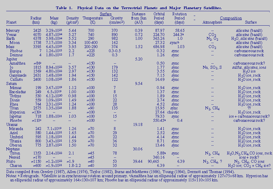
2.1. Physical data on planets and satellites
A summary of physical data on the terrestrial planets and major satellites is presented in Table 1.
2.2. Pre-spacecraft telescopic observations
Prior to the era of detailed spacecraft reconnaissance of the solar system, the primary means of obtaining planetary geology remote sensing data was via ground-based telescopes. Because of the limitations on resolution and image quality achievable by telescopic instrumentation, the scope of telescopic planetary geology was necessarily limited to observations of the Moon and Mars and less frequent observations of Mercury and large solar system satellites. Despite the limitations, much was learned about these terrestrial bodies through early telescopic drawings and photographs.
The earliest telescopic observations of the Moon allowed for the characterization of the gross geologic character of the lunar nearside at a spatial resolution as high as 1 km (e.g., Gilbert, 1893; Spurr, 1944; Baldwin, 1949). The obvious differences between the bright, mountainous highlands and the smooth, dark maria were attributed to flooding of depressions by fluid lavas. The nature of the regolith remained uncertain, with some scientists proposing a vast ocean of fine dust that might engulf landing spacecraft. The circular craters were obvious, but a significant degree of controversy raged as to their origin. One proposal suggested that they were formed by volcanic activity, whereas others believed them to be of impact origin. Pioneering work by E. Shoemaker and others in the early 1960s demonstrated the role of cratering on Earth (e.g., Shoemaker, 1963), and the first spacecraft lunar observations supported the interpretation that the Moon's surface processes are dominated by impact events. Color-difference methods and other simple photometric surveys illustrated the range of compositions among lunar basalts and were the precursor of later detailed spectroscopic analyses (e.g., Whitaker, 1966).
Early telescopic observations of Mars concentrated on characterization of surface albedo patterns and on monitoring of surface and atmospheric variability (e.g., Slipher, 1962; Martin et al., 1992). Geologic information was difficult to extract from drawings and photographs having spatial resolutions on the order of hundreds of kilometers, and observations by Schiaparelli, Lowell, Antoniadi, and others demonstrated that the interpretation of features observed on Mars was controversial and often highly subjective (Sheehan, 1988). Nonetheless, it was realized that the Martian surface is divided into at least two gross geologic provinces, bright regions and dark regions, and that the dark regions exhibit much greater evidence for temporal variability. It was also realized that Mars has a dynamic atmosphere that interacts with the surface on diurnal, seasonal, and interannual timescales, as evidenced by observations of local and global dust storms and the waxing and waning of the seasonal polar caps. The composition of the Martian surface was inferred from its color to be dominated by oxidized iron minerals (for a review of the earliest color and spectroscopic measurements, see de Vaucouleurs, 1954).
Spatially resolved telescopic observations of other terrestrial planets and satellites were extremely difficult using pre-space-age technology. Mercurian drawings and photographs compiled just before the turn of the century portrayed enigmatic and controversial surface markings that were never convincingly tied to specific surface geologic processes (see Chapman, 1988). Geologic observations of the surface of Venus at visible wavelengths are precluded by the inability to see below the thick clouds. However, radar echoes from the surface of Venus were first detected in 1961 and were later used to demonstrate that the planet rotates once every 243 days, such that a Venusian "day" lasts longer than its year (Shapiro, 1968).
2.3. History of planetary exploration missions
Since the early 1960s several nations have embarked upon an ambitious series of manned and unmanned planetary exploration missions (summarized in Table 2).


2.4. Planetary remote sensing techniques
2.4.1. Choice of Wavelength Regions for Planetary Applications. Remote sensing observations for the study of planetary geology span a wide variety of interests and applications. The specific object being observed or goal being addressed drives the choice of which region of the electromagnetic spectrum is appropriate. For example, surface mineralogy can be investigated using spectroscopy from the visible to infrared, because many minerals exhibit diagnostic absorption and emission features at these wavelengths. Geomorphologic information can result from broadband visible orbital imaging in the case of planets with thin to non-existent atmospheres. For planets with atmospheres, consideration must be made of the opacity of the atmosphere as a function of wavelength; in certain cases, such as for Venus, the only choice for orbital geomorphologic studies is microwave (radar) imaging.
In many cases, the final detailed choice of wavelengths to study may be dictated by instrumental considerations. Charge-Coupled Device (CCD) cameras, for example, which are now widely available for ground-based and space-based study of the planets, are often limited to operation in the 400 to 1100 nm region. Infrared detector technology is continually improving; however, the range of wavelengths available to an instrument is highly dependent on the composition of the detector and on the ability to cool the instrument below some optimal operating temperature.
2.4.2. Imaging Systems. Techniques for obtaining planetary images vary according to the specific wavelength region of interest. Early ground-based and spacecraft visible wavelength imaging relied upon photographic techniques, often supplemented by the use of broadband color filters. However, photographic film is a highly nonlinear detector that is extremely difficult to calibrate, so alternatives were sought which allowed for the derivation of more quantitative information from images. A major advance in spacecraft imaging after the film systems of Lunar orbiter was the vidicon, first successfully flown on the Mariner 4 flyby of Mars in 1965 (Leighton et al., 1967). Vidicon imaging systems work in a two step process: First, the photoconductive surface is exposed, much like film in a conventional camera, after an electron beam passes over the back of the photoconductor priming it with a negative charge. Photons incident upon the photoconductor surface reduce the negative charge in proportion to scene brightness. After this picture forming step, the resultant image on the photoconductor is read out by a scanning electron beam. The areas of the image with a less negative charge will draw more electrons for the beam, and this variation in current is read out as the video signal current. After readout, the image is digitized and sent back to Earth (Leighton et al., 1967; Danielson et al., 1975). Early vidicon images (Mariners, 4, 6 and 7) were crude and had low photometric accuracy by today's standards. However, they provided a dramatic first look at Mars. Improved vidicon cameras were extremely reliable with a photometric accuracy generally better than 10% (Mariner 10, Viking, Voyager). The photoconductive surface was sensitive to visible light in a range of about 350 nm to 650 nm. To obtain multispectral data a filter wheel was employed that allowed for several broadband filters typically placed between ~400 and 600 nm. Color filters led to the mapping of gross color heterogeneities on a scale of 1-10 kilometers for Mercury, Mars, and selected outer planet satellites (e.g., Soderblom et al., 1978; Rava and Hapke, 1987).
More recently, the CCD camera has replaced these previous visible wavelength instruments as the detector of choice. CCDs provide excellent dynamic range, linearity, and responsivity from the near-UV through the near-IR (with some modifications, their sensitivity range can extend from about 200 nm to 1110 nm). CCDs operate by allowing incident photons to produce a current in silicon-based semiconducting wafers or chips. The chips are divided into thousands or even millions of independent charge-collection regions called pixels ("picture elements"), and these pixels are organized into 2-D arrays in order to generate an image. The current in each pixel is a highly linear function of the incident photon flux, and most CCDs provide excellent quantum efficiency, or the ratio of induced photoelectron current to incident photon flux (e.g., Mortara and Fowler, 1981; Fowler et al., 1981).
High-quality imaging at near-IR and mid-IR wavelengths has recently become practical because of advances in infrared-sensitive arrays. Specifically, arrays constructed from indium and antimony (InSb) substrates have had spectacular success in achieving high Signal to Noise Ratio (SNR) and high dynamic range for telescopic and spacecraft imaging applications. Other IR sensitive substrates, including silicon-arsenic (SiAs), germanium (Ge), and indium-gallium-arsenic (InGaAs), have also been used with good results. A particular advantage of many of these arrays is their ability to operate effectively with only modest cooling requirements. Ge and InGaAs arrays, for example, can operate effectively even at temperatures as high as 250-270 K. InSb arrays can produce good data when cooled to liquid nitrogen temperatures (77 K), although they perform even better at liquid helium temperatures (~ 4 K).
Imaging at microwave wavelengths from a few millimeters to several millimeters forms the basis of radar remote sensing systems. Active systems use a powerful transmitter to illuminate the target surface and sensitive receivers to pick up the faint echoes reflected by the surface materials. By carefully measuring the time delay and Doppler shift of returned signals, a radar echo map can be produced. The radar echo is influenced by local slopes, by roughness at the scale of the wavelength, and by the dielectric properties of the surface. By varying the incidence angle, polarization, and wavelength of the illuminating energy, a more complete estimate of the surface properties can be obtained. More details on radar remote sensing can be found in Ostro (1983) and Butrica (1996). Passive microwave systems exploit the fact that all materials radiate energy received from the Sun or internal sources in a characteristic wavelength distribution described by the Planck function. This distribution is strongly dependent on the temperature of the surface and its emissivity (the efficiency of the material in emitting energy to its surroundings). Measurement of the amount of energy radiated from a surface at different wavelengths can thus be used to constrain these and other important surface parameters (e.g., Muhleman, 1972).
2.4.3. Spectroscopy. Spectroscopic remote sensing observations can provide substantially more diagnostic compositional and mineralogic information on planetary surfaces than imaging alone (cf. Chapters 1 and 6). Essentially three types of spectroscopic observations can be obtained: X-ray and gamma-ray spectra, reflectance spectra, and thermal emission spectra. Each offers specific advantages for answering certain types of compositional or mineralogic questions.
X-ray and gamma-ray spectra provide diagnostic information on the abundances of specific elements in the outermost layers of a planetary surface. These spectroscopic techniques take advantage of the fact that high energy galactic cosmic ray particles and lower energy solar X-rays and charged cosmic ray particles penetrate up to several centimeters into the surface and excite X-ray radiation that is characteristic of specific elements. This secondary radiation is then emitted from the surface and can be detected using both scintillator and semiconductor detectors at gamma-ray energies and gas-filled proportional counters at X-ray energies. These techniques can provide quantitative information on the abundances of many rock-forming minerals (e.g., Na, Mg, Al, Si, P, S) as well as on the abundance of natural radioactive materials (K, Th, U) and hydrogen. Detailed additional information on X-ray and gamma-ray remote sensing techniques can be found in Evans et al. (1993) and Yin et al. (1993).
Reflectance spectroscopy provides diagnostic information on the mineralogy and degree of crystallinity of the uppermost few microns of a planetary surface. This technique involves measuring the spectrum of sunlight reflected from a planetary surface, and is thus restricted to the wavelength range where the Sun's flux is highest and where the amount of energy reflected from the object is greater than the amount that is thermally emitted (the typical wavelength range is from 0.3 to 3.5 um). Many materials, including primary and secondary minerals, exhibit electronic spectral features and vibrational overtone bands at these solar wavelengths. Reflectance spectra reveal absorption features that are characteristic of certain minerals and ices and/or indicate the presence of certain cations. For example, the mineral pyroxene, a common component of basaltic rocks on the Earth, can be detected remotely by the measurement of diagnostic absorption features near 1.0 and 2.0 um. Variations in the abundances of Fe and Ca in the pyroxene can also be inferred based on subtle shifts in the positions of these bands. Reflectance spectroscopy is currently the most useful technique for remotely measuring the mineralogy of planetary surfaces, and specific minerals have been identified on the Moon, Mars, and a number of asteroids. Additional detailed information on reflectance spectroscopy theory and techniques can be found in Burns (1993) and Gaffey et al. (1993).
Thermal emission spectroscopy also provides diagnostic information on the mineralogy of planetary surfaces, as well as additional information on surface thermophysical properties like temperature and thermal inertia. Most of the major rock-forming minerals exhibit their fundamental molecular vibration spectral features at mid-infrared wavelengths, typically from 3.0 to 25.0 um, where thermal radiation emitted from planetary surfaces at temperatures from 200 to 400 K dominates over reflected sunlight. Unlike reflectance spectra, thermal IR spectra can exhibit features in both emission and absorption, depending on the nature of the planetary environment. Thermal IR spectra are more difficult to interpret, but they also allow the potential, through radiative transfer modeling, to infer additional information about a planetary surface such as emissivity, particle size and degree of compaction, and the subsurface temperature profile (e.g., Hapke, 1996). Thermal emission spectra have been used, for example, to obtain remote compositional information on variations in terrestrial basaltic lava flows and to constrain the thermal inertia and rock abundance of the Martian surface (e.g., Christensen, 1986; Kahle et al., 1993). More details on the theory and application of thermal emission spectroscopy can be found in, for example, Salisbury et al. (1991), Hanel et al. (1992), and Salisbury (1993).
2.4.4. Imaging Spectroscopy. The spectroscopic techniques discussed above have typically been constrained by instrumentation to obtain compositional or mineralogic information only for specific, possibly small places on planetary surfaces. The imaging techniques discussed above have traditionally been used primarily for obtaining morphologic information, at the expense of more detailed compositional or mineralogic data. A recent and important development in remote sensing is the combination of imaging and spectroscopic techniques to allow for the determination of compositional information and the mapping of this information across a planetary surface at high resolution.
Reflectance imaging spectroscopy measurements are currently based on two different techniques. The first technique is to combine an imaging instrument with a modest number (8-24) of discrete narrowband filters placed at key wavelengths for the detection of specific minerals and/or ices. The result is a high spatial resolution dataset at high enough spectral sampling and resolution to allow for the mapping of various spectral units. The tradeoff for this method is that not all of the wavelengths can be obtained simultaneously, so spacecraft motion or other variable effects act to introduce uncertainties into the data. The second technique is to combine a spectrometer with a 2-dimensional array to allow for the spectra of different spatial locations to be obtained simultaneously. The result is a high spectral resolution data set at high enough spatial resolution to again allow for the mapping of surface units. The tradeoff for this method is that only one axis of spatial information can be obtained at a time, so in order to build an image, the second axis of spatial information must be obtained by scanning the instrument and/or moving the spacecraft. The former approach has been used very successfully by ground-based and Hubble Space Telescope observations of the Moon, Mars, and asteroids, and on the Galileo and Clementine spacecraft missions. The latter technique has also been successfully used by ground-based observers and by instruments on the Phobos-2 and Galileo missions. The choice of technique depends primarily on the importance of obtaining high spectral resolution. For cases where lower resolution is adequate, the discrete filter technique offers excellent image quality; for cases where detailed compositional or mineralogic information is required, then spatial image quality must be sacrificed for higher spectral resolution. More details on the theory and implementation of imaging spectroscopy can be found in Adams et al. (1993) and Vane et al. (1993).
3. Primary Planetary Surface Modification Processes
This section provides a brief overview of the four major surface modification processes that can act on a planetary surface and that can be characterized by planetary geologic remote sensing observations. These processes include the three primary processes most often studied by terrestrial geologists (volcanism, tectonism, and gradation), and a fourth process that often dominates the geology of many planetary surfaces (impact cratering). Most of our knowledge of these processes is based on the study of geologic features on the Earth. As such, an important part of planetary geology is determining how these features may vary due to the action of surface modification processes on other planets.
3.1. Impact cratering
In the context of planetary geology, impact cratering may be the single most important surface modification process at work in the solar system
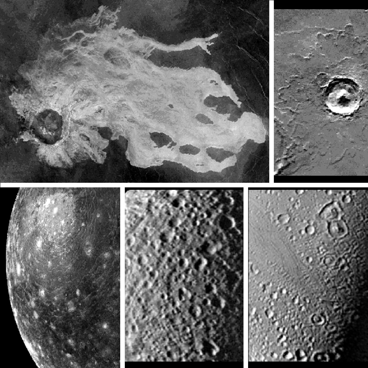 Figure 2 Caption |
The impact process involves the transfer of energy from the impactor, known as a bolide, to a planetary surface. Bolides can range in size and composition from small meteoroids to larger asteroids and comets to large planetesimals. The amount of energy transferred determines the overall geologic consequences and is a function of the size, velocity, composition, and strength of the bolide and the physical and environmental conditions of the target surface (gravity, composition, atmospheric pressure).
Four physically distinct stages of impact crater growth are recognized to occur (Taylor, 1982): (1) Collision and transfer of the bolide's kinetic energy into the surface through a shock wave; (2) Rarefaction of the shock wave and decompression of the crustal materials traversed by the compressive shock wave; (3) Acceleration of materials disrupted by the rarefaction wave resulting in excavation of the crater cavity; and (4) Subsequent readjustment of the transient crater cavity mostly due to gravitational forces and relaxation of compressed target materials.
Most energy transfer takes place via the compressive shock wave as thermal energy and as kinetic energy through ballistic ejecta and movement of materials within the cavity. Peak pressure may be as high as 5000 kbar (impact velocity of 15-25 km/sec). Materials under pressure >700 kbar are generally molten (thought to be less than 10% of the excavated volume).
The final crater modification stage is complex and includes fallback of ejecta into the cavity, the emplacement of ejecta blankets preserving an inverted stratigraphy in the region adjacent to the crater, collapse of the walls of the transient crater cavity, rebound of the crater center (uplift), seismic shaking, and the formation of impact melt sheets which drape much of the crater topography [e.g., Fig. 2]. Details on the physics and mechanics of impact processes can be found in Shoemaker (1963), Gault et al. (1968), Roddy et al. (1977), Hartmann (1977), Kieffer and Simonds (1980),and Greeley (1987).
Because impact cratering involves the random collision of objects in the solar system, older surfaces have a higher likelihood of being struck by bolides. The observed density of impact craters per unit surface area thus provides a measure of both the relative age of the surface and the amount of modification experienced by that surface over its geologic history. Considerable effort has been expended trying to determine an absolute age scale based on the technique of counting the number of craters per unit surface area and dividing by an estimate of the flux of incoming bolides per unit time (e.g., Shoemaker, 1966; Shoemaker et al., 1970; Neukum et al., 1975). This age dating tool has been fairly successful for determining absolute ages of lunar surface units which have been validated by radiometric dating of returned Apollo lunar samples. However, impacts are the dominant surface modification process on the Moon, and substantial problems need to be overcome in order to apply this surface age dating technique to other solar system objects with more varied geologic histories and cratering rates. For example, not all circular features seen in planetary images may be of primary impact origin (they may be related to volcanic events, karst, secondary cratering events, etc.). Also, studies have shown that surfaces can reach a crater saturation value when the creation of new craters destroys evidence of previously existing craters (Gault, 1970). Such surfaces cannot be accurately calibrated to an absolute age scale. Despite these limitations, impact crater statistics can be effectively used as a means of establishing a relative age sequence among different planetary surfaces and surface units.
3.2. Volcanism
Volcanism involves the melting of materials within a planet and the transport or eruption of these materials onto a planetary surface. For most surfaces the melted material is silicate-bearing rock, called magma. The most common magma on the terrestrial planets is of basaltic composition (e.g., Cas and Wright 1988). However, volcanism involving molten sulfur or ices of various compositions has been found or postulated to exist on a number of outer solar system objects
 Figure 3 Caption |
Volcanic landforms exhibit a wide range of morphologies that are a strong function of planetary physical and environmental conditions, physical and chemical properties of the magma, and the style and mechanics of the eruption (Whitford-Stark, 1982). The most common volcanic landforms in planetary geology are basaltic lava flows, shield volcanoes, cinder cones, and lava channels [Fig. 3]. Terrestrial volcanic landforms have been studied in great detail both as a means of obtaining information on the thermal evolution and interior characteristics of the Earth as well as providing a comparative basis for the study of volcanic landforms on other planets (e.g., Basaltic Volcanism Study Project, 1981; Greeley and King, 1977; Carr and Greeley, 1980). Detailed compilations and analyses of planetary volcanic features can be found in Head (1976), Plescia and Saunders, (1979), Greeley and Spudis (1981), Whitford-Stark (1982), Wilhelms (1987), and Mouginis-Mark et al. (1992).
3.3. Tectonism
Tectonism involves the deformation of the lithosphere of a planet, driven by either internal (volcanic, tidal, radioactive) or external (impact) forces. Tectonic processes manifest themselves as distinctive morphologic features like faults, fractures, and folds, and the specific characteristics of these features can often be used to infer the local style of deformation that has occurred
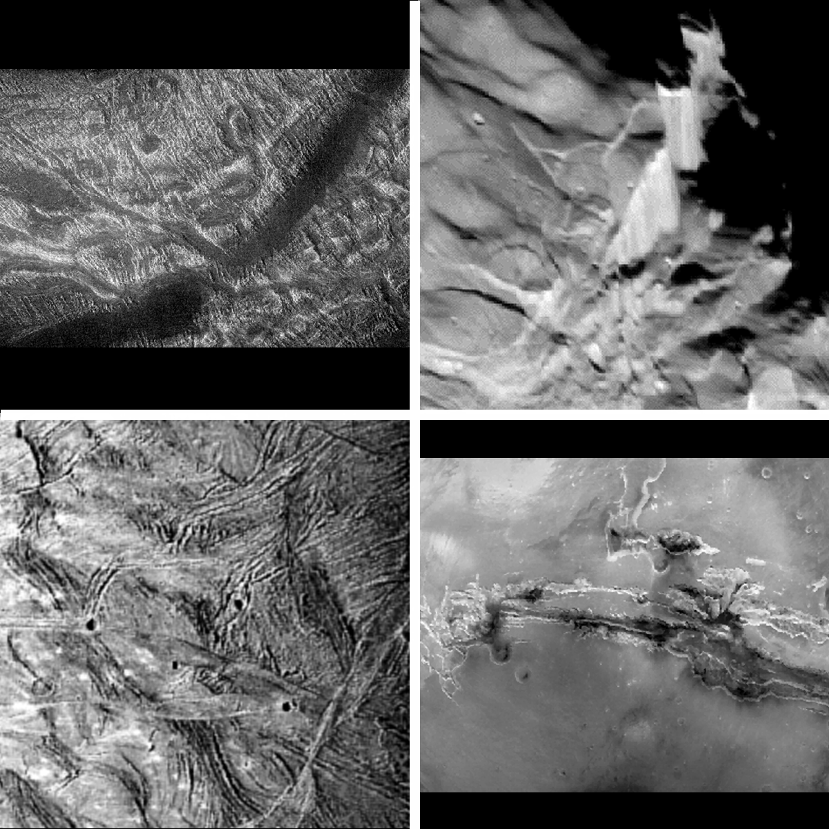 Figure 4 Caption |
The global-scale interpretation of tectonism on other planets has been greatly influenced by the discovery and understanding of plate tectonics on the Earth. The Earth's lithosphere is divided into numerous plates of different sizes, each moving at different rates and all floating atop the semi-molten upper mantle layer called the asthenosphere (e.g., Cox and Hart, 1986). This results in complex systems of tectonic features that are often difficult to uniquely interpret from regional- or global-scale remote sensing views. In contrast, most other planetary surfaces are thought to be single-plate surfaces with much thicker lithospheres. Global-scale tectonic features on these planetary surfaces are formed by much simpler extensional and compressional forces (such as uplift or cooling), and thus their interpretation via remote sensing techniques is, most often, more straightforward though still complex (e.g., Head and Solomon, 1981).
3.4. Gradation
Gradation involves the wearing down of topographic highs and the filling in of topographic lows on a planetary surface. This process of erosion and deposition is driven by gravity and is strongly influenced by environmental factors such as atmospheric pressure and density and surface temperature and composition. The primary means of moving materials by gradation come from the actions of liquid water, ice, wind, and mass wasting (the downslope movement of rock and debris). Each of these processes produces characteristic morphologic features that are often detectable by remote sensing
 Figure 5 Caption |
The effects of gradation are most pronounced on planets having atmospheres, since an atmosphere is an obvious prerequisite for the formation of aeolian features, and an atmosphere that contains or once contained water is required for the formation of hydrologic and glacial/periglacial features. Aeolian features have been observed on Mars, Venus, and Triton, and gradational morphologies related to both liquid and frozen water have been observed on Mars. Mass wasting does not require the presence of an atmosphere, and features related to mass wasting have been observed on the Moon, Mercury, and Mars. The absence of surface water on Venus precludes fluvial or other hydrologic features, and mass wasting has thus far been identified primarily in association with steep-sided tectonic troughs and volcanic domes (e.g., Malin, 1992).
4. Geology of the Terrestrial Planets
This section provides a brief background on the geology of the terrestrial planets: Mercury, Venus, Earth, and Mars as well as the Moon. The information presented here is a starting point containing general background information and a discussion of some previous and current controversies. Much more detailed information on each of these bodies can be found in the references and recommended reading cited at the end of this chapter.
4.1. Mercury
Of the terrestrial planets, Mercury is the most poorly understood. Only half of its surface has been imaged by a spacecraft
 Figure 6 Caption |
A first order question when studying any planet is the bulk composition of its crust. However very little is known of the composition or mineralogy of the Mercurian crust. Earth-based visible to near-infrared spectroscopic measurements indicate that Mercury has no gross hemispherical mineralogical differences (e.g., Vilas, 1988). Due to Mercury's high bulk density it is thought to have a large core and a high bulk Fe content, probably twice as much Fe as any other planet (c.f. Chapman, 1988). However, there is no direct evidence of a high Fe content in the crust (Vilas, 1988; Rava and Hapke, 1987; Cintala, 1992). More recent mid-infrared spectroscopic observations reveal evidence for plagioclase or anorthite minerals on the surface with a lower oxidized iron content than similar minerals on the Moon (Sprague et al., 1994). Perhaps most surprisingly, recent Earth-based radar observations of Mercury have revealed anomalously radar-bright regions near the poles. Analyses have determined that these areas are confined to the interiors of large, permanently shadowed craters, raising the possibility of the presence of subsurface ice in these regions (e.g., Slade et al. 1992, Butler et al., 1993). However, there is skepticism about the possibility of polar ice on Mercury, and alternate hypotheses have been presented to explain the radar bright regions (e.g., Sprague et al., 1995).
The Mariner 10 flyby images revealed the Mercurian surface to be lunar-like [Fig. 6]. Four primary physiographic units were identified: heavily cratered terrain, intercrater plains, smooth plains, and hilly and lineated terrain (Trask and Guest, 1975; Davies et al., 1978; Spudis and Guest, 1988). The heavily cratered terrain is very similar to the lunar highlands, with densely packed and overlapping craters of all sizes and little evidence for discrete ejecta blankets and secondary crater fields. The origin of the heavily cratered terrain is probably similar to that of the lunar highlands, representing the consequence of heavy bombardment by impacts early in solar system history. The intercrater plains unit covers more than a third of the area imaged by Mariner 10, and is thus the most extensive physiographic unit yet mapped on Mercury. The unit is characterized by gently rolling plains extensively covered by small impact craters. Its origin is unclear, as it appears to predate the heavily cratered terrain in places, but postdate it elsewhere. Smooth plains resemble the lunar mare in many ways: they have fewer craters than surrounding units, are relatively flat, many have sinuous or arcuate ridges, and they often fill large craters or embay older terrains (c.f. Spudis and Guest, 1988). Most of the smooth plains deposits on Mercury are concentrated near the 1300-km diameter Caloris impact basin. Morphologic and stratigraphic arguments were initially made arguing that these plains are of volcanic origin, like the lunar mare (Murray et al. 1974; Strom et al., 1975) Subsequent analysis proposed that the Mercurian smooth plains are ejecta deposits from a large impact, such as the Caloris basin forming event (Wilhelms, 1976). Wilhelms deduced that the smooth plains deposits were analogous to the lunar Cayley plains deposits that were also initially mapped as volcanic deposits -- later proven wrong by the return of Apollo 16 samples. Also, the albedo of the smooth plains is the same as the surrounding units, implying the smooth plains do not have a different composition. The Mercurian hilly and lineated terrain consists of a fragmented assemblage of hills, massifs, and depressions centered on the region antipodal to the Caloris impact basin. This terrain possibly was formed by the focusing of surface and interior seismic energy associated with the Caloris event and the subsequent jostling, lifting, and thrusting of the surface (Schultz and Gault, 1975).
Despite the many similarities, important differences exist between the geology of Mercury and the Moon. For example, impact craters on Mercury have smaller ejecta blankets, brighter ray systems, and deeper, less extensive secondary crater chains. Most of these differences have been associated with the higher gravity on Mercury relative to the Moon (e.g., Gault et al., 1975; Scott, 1977). Also, morphologic differences between impact craters in the heavily cratered terrain and those in the lunar highlands argue for differences in the physical properties of these surfaces (Cintala et al., 1977). Finally, an extensive system of scarps and ridges on Mercury provides evidence for compressional tectonism on the surface, perhaps resulting from the early cooling and shrinkage of a putative large iron core (e.g., Dzurisin, 1978; Strom et al., 1975).
4.2. Venus
With a diameter and bulk density nearly the same as the Earth, Venus is often described as our "sister planet". Remote and in situ observations over the past thirty years have shown that this comparison is correct in some ways, but that the two worlds have experienced very different climatic and geologic histories. The surface of Venus is completely hidden beneath a thick blanket of clouds. Earth-based telescopes and visible-wavelength sensors in orbit never view the ground, so our understanding of this planet's topography and surface properties relies almost entirely on remote sensing observations using microwave systems.
Early telescopic observations of Venus revealed the presence of a thick cloudy atmosphere, leading to speculations as to the possibility of life. Spectroscopic analysis demonstrated that the atmosphere was dominated by carbon dioxide, with sulfuric acid clouds forming the opaque shield above the surface. The upper layers of the atmosphere circle the planet every four days in a phenomenon known as "super-rotation". These observations made it clear that the atmosphere of Venus differed markedly from that of Earth, but what was the surface like? Because longer wavelength signals could penetrate the cloud layer and return from the surface, such observations were the logical next step.
The microwave emission from Venus was measured using Earth-based radio telescopes beginning in 1956 (Mayer et al., 1958), leading to the immediate conclusion that the surface of our sister world is far too hot to support life, with a mean temperature of 740 K (above the melting point of lead). This result was confirmed by early spacecraft flybys, including Mariner 2 in 1962, the first successful interplanetary mission. Further spectroscopic work demonstrated that Venus has little atmospheric water (Janssen et al., 1973), and a series of Soviet descent probes showed that the surface pressure was a crushing 90 times that of Earth (e.g., Moroz, 1983). Winds in the upper atmosphere race along with the four-day rotation, but near the surface the average speed is only about 1 m/sec. Under this dense atmosphere, there is little change in temperature from day to night. Current models suggest that Venus experienced a "runaway" greenhouse effect early in its history, with the thick CO2 atmosphere trapping large amounts of incident solar radiation. The potential for life was gone, but the study of the geology and properties of Venus using radar developed rapidly.
Earth-based radar maps of the planet improved steadily in resolution from hundreds of kilometers in the 1960s to a current capability of about 1 km. In 1980, the Pioneer-Venus (PVO) spacecraft produced the first global topographic database for the planet. This mapping (reviewed by McGill et al., (1983)) revealed a surface dominated by vast plains (found by Venera landers to be most likely composed of basaltic material
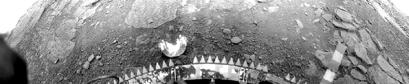 Figure 7 Caption |
The Magellan mission, which operated in Venus orbit from 1990-1993, provided a near-global radar map of the planet at resolutions of ~100 m (Saunders et al., 1992). At the same time, the surface elevation and microwave emission were mapped at somewhat coarser scales. These observations have led to a vigorous and ongoing debate as to the past history and current state of the Venusian lithosphere. The impact crater population can be used to show that the surface is far younger, on average, than that of the Moon or Mars, with a mean age of perhaps 300-500 m.y (e.g., Schaber et al., 1992). A global resurfacing event of this age seems necessary to explain the crater data, but the mechanism by which this occurs and the likelihood of periodic crustal overturn remains contentious. Volcanic eruptions have clearly modified the surface, with large shield volcanoes concentrated along the equatorial highlands and thousands of smaller domes, shields, and cones distributed across the plains
 Figure 8 Caption |
Venus remains an enigmatic neighbor, and the past 30 years of research have only broadened our knowledge of the differences between the Earth and its sister. Major issues remain to be addressed in terms of atmospheric evolution, the history of the surface and how it is recycled over time, and surface heat flow and mantle processes. Future observations will likely include additional Earth-based radar mapping of the planet, spacecraft atmospheric probes, and perhaps new surface landers or near-surface imaging systems.
4.3. Earth
A detailed discussion of terrestrial geology is beyond the scope of this chapter, but it is instructive to include a brief mention of Earth here as part of planetary geology because terrestrial geology provides our primary context for the interpretation of remote sensing data from other planetary surfaces. Remote sensing observations of the Earth can be supplemented with ground truthing and detailed laboratory analyses, providing important information on the types of processes that can be identified using remote sensing and those that cannot.
The earliest and best-known terrestrial remote sensing method is aerial photography, and basic photographic products are now common spacecraft datasets. These images are used for a variety of purposes, including agricultural monitoring, hazards monitoring, geologic studies, urban planning, ocean and coastal watches, and weather prediction. Remote sensing of geologic processes was spurred by the development of camera systems that obtain data in both visible and infrared wavelengths. Because many minerals have characteristic absorption bands in the near- and mid-infrared, many systems such as the Landsat Thematic Mapper (TM) utilize spectral channels that emphasize differences in IR reflectivity between units. Variations in mineral hydration are often mapped in this fashion, and the same techniques can be used to study vegetation health (by the strength of chlorophyll absorption), ocean color, and urban growth. Thermal infrared remote sensing began with single-channel sensors such as the Landsat TM band 6, which provides a measure of radiant flux from a target surface. More advanced instruments utilize multi-channel thermal IR systems to characterize surface mineralogy.
Microwave measurements include both active remote sensing using aircraft and spacecraft radars and passive emission observations at shorter wavelengths. The ability of radar to penetrate clouds makes it ideal for mapping areas where traditional photography is difficult, such as in tropical or mountainous regions, and allows all-season monitoring of surface processes. At shorter wavelengths, radar signals will interact with water in the atmosphere and be reflected back to the receiver, providing the basis for weather observations. Measurement of the Doppler shift of returned echoes allows determination of wind velocities. Orbital radar systems are also used to measure ocean wave spectra (and to infer wind speeds) and to accurately measure surface elevations.
Earth is the largest of the terrestrial planets and is also the most geologically active. The crust is constantly recycled by plate tectonics, wherein new ocean floor is created at mid-ocean ridges and consumed at subduction zones. Convective patterns within the mantle drive the plates above them, leading to a cycle of collisions between the buoyant continental landmasses and producing mountains and other features. Unlike any other terrestrial body, there is abundant liquid water, and the cycling of this water through the atmosphere, crust, and oceans has a major effect on surface weathering and mineralogy. The Earth is our reference point for comparative planetology, and many remote sensing techniques used in planetary exploration are validated through practical terrestrial applications. The development of space technology has led to a fundamental change in studies of terrestrial processes. Where once local events and patterns dominated fields of study, we now can examine the global links between geologic, hydrologic, and atmospheric systems using remote sensing. Optical, infrared, and radar sensors have developed at astonishing rates since the 1950's, and current plans call for satellites capable of monitoring global changes through an array of combined techniques.
4.4. The Moon
Aside from the Earth, we know more about the Moon than about any other object in the solar system. The Moon has provided a fundamental and critical testing ground for almost all of the currently used planetary geologic remote sensing techniques, from ground-based telescopic observations to robotic orbiters and landers to human exploration and sample return. As well, the proximity and relatively straightforward geology of the airless lunar surface has been important in the theory, development, and testing of the various fundamental tenets upon which the field of planetary geology is based.
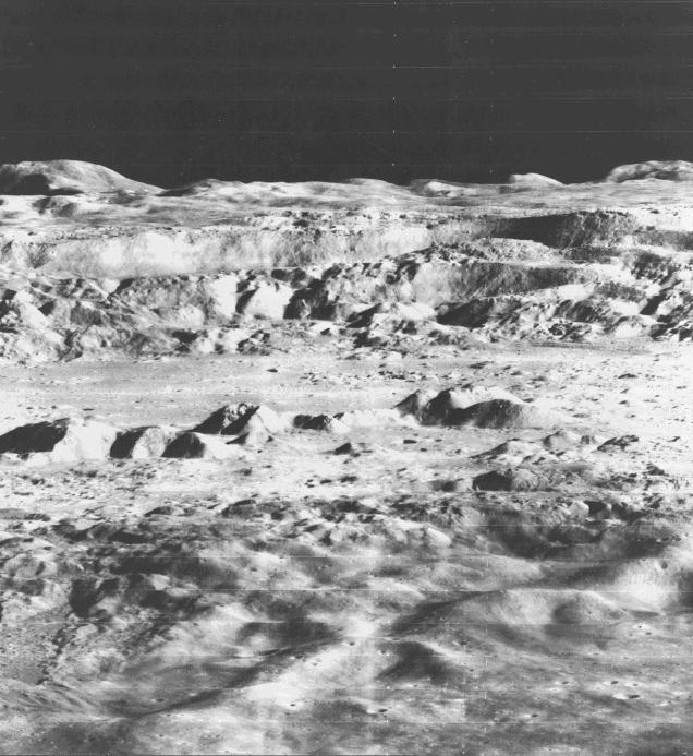 Figure 9 Caption |
The physiography of the Moon can be divided into three primary terrain types: heavily cratered highlands terrains, impact basins and associated structures, and mare regions (e.g., Wilhelms, 1987). The highlands are bright (9 to 12% albedo), rugged, heavily cratered terrains with little or no evidence for discrete ejecta blankets or secondary crater fields. Highlands terrains compose nearly 70% of the nearside of the Moon and 98% of the farside
 Figure 10 Caption |
Associated with the basins are extensive areas of surrounding highlands terrain that have been modified by the degradational action of material ejected during basin-forming events. In many cases, discrete basin ejecta deposits or their effects on pre-existing terrain can be traced for several thousand km beyond the basin rim. Mare regions are relatively smooth, dark (5 to 8% albedo), usually circular regions that are almost always confined to the interiors of basins or large craters (Stuart-Alexander and Howard, 1970). Crater counting statistics indicate that these regions are clearly younger than the surrounding highlands and other basin terrains. Their origin as lava flows analogous to terrestrial flood basalts has come primarily from morphologic studies that revealed evidence for volcanic features such as flow fronts, vents, and lava channels. The higher concentration of mare units on the Earth-facing side of the Moon is thought to result from the near side having a thinner crust than the far side (e.g., Bills and Ferrari, 1977), resulting in easier transport of magma through the nearside crust. The thickness of the mare deposits is estimated to be less than 4 km in most place (e.g., Hörz, 1978), so their total volume comprises less than 1% of the lunar crust.
 Figure 11 Caption |
Earth-based spectroscopic observations, confirmed with returned samples, revealed that the dark mare regions are mostly composed of clinopyroxenes (high calcium) and plagioclase feldspars, with lesser amounts of olivine and ilmenite, while the brighter highlands regions are dominantly anorthite with varying amounts of orthopyroxene (low calcium) and olivine (see reviews in Heiken et al., 1991; Pieters, 1993). These minerals possess distinctive spectral signatures in the wavelength range 400-2500 nm, thus it has been possible to map their areal distribution for much of the Moon through remote sensing techniques (e.g. Pieters, 1993; Nash et al., 1993).
The most intense phase of lunar exploration occurred during the Apollo manned landing program. Twelve astronauts explored the lunar surface at six different sites, using a combination of drilling, sampling, traversing, and other analysis techniques to return 382 kg of rocks and soils to Earth for analysis [Fig. 1] (Heiken et al., 1991). Some of the most profound results of the Apollo program include the determination of an absolute age-dating chronology for the lunar surface, the identification of the impact (as opposed to volcanic) origin of highlands plains units, and the detailed characterization of lunar regolith mineralogy and mineralogic diversity. Remote sensing instruments in the Apollo orbiting Command and Service Module obtained unique photographic, geochemical, topographic, and other data about the Moon (Masursky et al., 1978). The unmanned Luna sample return missions between 1970-1976 returned 300 g of lunar samples from three other sites, and in situ measurements were conducted by Surveyor and Luna landers. Samples and data gathered by these missions have allowed a detailed characterization of the geology and mineralogy of the landing sites and their surrounding terrains. Many of the results obtained from these focused investigations have been used to infer details on the origin of the Moon and its global-scale geology and composition (e.g., Hartmann et al., 1986; Heiken et al., 1991; Wilhelms, 1987).
Spectroscopic observations and detailed analyses of samples from the six Apollo missions reveal that the surface of the Moon is a volatile-free, chemically reducing environment subject to extreme ranges of surface temperature and prolonged periods of solar wind and galactic cosmic ray bombardment. Under these conditions, there is a limited range of rocks and minerals that can form and/or exist stably on the lunar surface. The materials on the lunar surface can be classified into 2 main categories: (1) Soil/Regolith: Fine-grained rock and mineral fragments produced by constant impact comminution at all size scales. Soils are divided into "mature" and "immature". Mature soils, because of their longer exposure ages, have enhanced abundances of glass and agglutinates (particle aggregates bonded by impact produced glass) and are typically darker and redder than their immature counterparts. Immature, or fresh soils, have much lower abundances of agglutinates (higher relative abundances of crystalline mineral phases). (2) Rocks: The classical albedo division of the Moon into highlands (bright) and mare (dark) can also be used to describe the two major sets of lunar rock types. Mare rocks are basaltic lavas that are primarily composed of pyroxene, plagioclase, olivine and opaque metallic oxides of varying composition, all of which may have widely varying iron, titanium, and aluminum abundances. Highlands rocks are dominated by plagioclase (anorthosites), pyroxene, and olivine, and have typically been pulverized and vitrified by impacts into unsorted, welded aggregates of material called breccias. Other, rarer lunar phases such as quartz and potassium feldspar have been detected in returned samples, but for the most part the mineralogy of the Moon is made up primarily of plagioclase, pyroxene, olivine, and ilmenite. In this regard the Moon is a much less complex geologic object than the Earth or Mars.
The most recent phase of lunar remote sensing has involved the use of more advanced telescopes and instrumentation (such as imaging spectroscopy) for increased spatial and spectral resolution studies of the near side (e.g., Johnson et al., 1991; Jaumann, 1991; Bell and Hawke, 1995; Blewett et al., 1995), as well as multispectral imaging carried out by the Galileo (Belton et al., 1992a) and Clementine spacecraft (Nozette et al., 1994) [Fig. 10]. These investigations have revealed substantial crustal heterogeneity on the Moon and allow characterization of lunar surface geology and mineralogy at higher spatial resolution than ever before. In particular, analyses of the global high resolution Clementine data to determine mineralogic and compositional abundances, which is just now beginning, are certain to fundamentally enhance our view of lunar geology (e.g., Lucey et al., 1995).
4.5. Mars
Mars has fascinated both scientists and the general public because it is the most Earthlike planet in the solar system. Mars has a dynamic atmosphere (though only 1% as dense as Earth's), seasons similar to the Earth's (though roughly twice as long), and a rotation period very close to 1 Earth day. It has towering volcanoes, vast canyons, water-carved channels, frequent and sometimes global-scale dust storms, and polar caps that wax and wane with the seasons. It has been the focus of major ground-based, Hubble Space Telescope (HST), and spacecraft remote sensing and in situ observations and missions, and it is an obvious choice for future human exploration missions early in the 21st century.
The earliest geologic studies of Mars came from ground-based telescopic observations during periods when Mars and Earth were closest and the spatial resolution approached 100 km under the best terrestrial atmospheric conditions (see review by Martin et al., 1992 and section 2.2). These studies revealed two major surface units: bright and dark regions, along with detailed characterizations of the growth and decay of the polar caps. The bright and dark regions are organized into a series of albedo patterns that have been fairly constant for at least hundreds of years, except for usually short-timescale seasonal or interannual variations due to dust storms. Speculations on the composition of the surface centered on oxidized iron (Fe3+), based on the extremely red color of the bright regions, found to be similar to that of many oxidized terrestrial desert rocks and soils (de Vaucouleurs, 1954; Mutch et al., 1976). Spectroscopic observations in the 1960s and 1970s began to quantify the color differences among various regions and indicated that the dark regions contain the mineral pyroxene, linking them to a volcanic origin (e.g., Adams and McCord, 1969; McCord and Adams, 1969; Singer et al., 1979). More recent ground-based and HST telescopic observations in the 1980s and 1990s have revealed even more evidence for mineralogic variability among and between bright and dark areas on Mars (see review in Bell, 1996).
 Figure 12 Caption |
 Figure 13 Caption |
While the primary data showed that the surface regions examined have only trace levels of organic material (the ppb level or less), high resolution imaging and a variety of other secondary direct soil sampling experiments provided basic information on the chemical composition, magnetism, and other physical properties of the soil
 Figure 14 Caption |
The general physiography of Mars is divided into numerous different terrain types, the most extensive being heavily cratered regions, plains, and volcanoes (Mutch et al., 1976; Carr, 1981). The heavily cratered regions occur mostly in the southern hemisphere, and are separated from smoother and possibly topographically-lower northern plains regions by a global-scale boundary scarp. The origin of this north-south hemispheric dichotomy is unexplained, but gravity measurements and morphologic studies point to a thinner crust in the northern lowlands, possibly related to a giant impact early in Martian history (see Smith and Zuber, 1996) or perhaps a Martian version of plate tectonics (Sleep, 1994). Most of the large impact basins on Mars are found throughout the heavily cratered regions as well (e.g., Schultz et al., 1982), attesting to its great age. Unlike the heavily cratered regions on the Moon and Mercury, however, this terrain on Mars appears to have been substantially eroded by the actions of wind and water and perhaps ice over geologic time. Many of the craters have degraded rims and/or flat, filled floors, and some have branching networks of valleys putatively of fluvial origin (e.g., Carr, 1981).
Volcanism has been an important surface modification process on Mars, as evidenced by the number and variety of volcanic features and constructs
 Figure 15 Caption |
Other important physiographic features include: channels that debauch into basins and other lowlands and which were likely formed by vast flooding events; a vast system of tectonically created canyons stretching for more than 4000 km along the equator near the Tharsis volcanic region; fretted, knobby, and "chaotic" terrains that have been extensively modified by degradational processes; polar ice caps composed of both water and CO2 ices; and polar layered terrains consisting of alternating bands of bright and dark material that may be an indicator of seasonal or longer-term cyclical climatic changes. A more complete discussion of these various units and of the general geology and stratigraphy of Mars is not possible here, but detailed reviews can be found in Mutch et al. (1976) and Carr (1981).
Geologic study of Mars over the past decade has concentrated on the continued refinement and analysis of the Viking imaging data in preparation for the next wave of spacecraft exploration to be carried out by the Mars Global Surveyor orbiter and Mars Pathfinder lander missions in 1997-1999. In addition, continued ground-based and HST observations are providing additional constraints on surface mineralogy and surface/atmosphere interactions.
5. Geology of Asteroids, Comets, and Meteorites
There are currently over 6000 asteroids and nearly 500 comets in the solar system with well-determined orbits. In addition, there are a small number of planetary satellites (such as Phobos and Deimos) that are almost certainly captured asteroids. These objects represent only a small fraction of the total number of asteroids and comets, as only the largest, brightest, and nearest objects have been observed. The total number of main-belt asteroids (dominated by small objects between 2 and 4 AU) is likely in the many tens of thousands, and there are perhaps an order of magnitude more objects in the Kuiper Belt beyond the orbits of Neptune and Pluto (Jewitt and Luu, 1995). The total number of comets (originating in the Öort cloud, a huge sphere of comets between approximately 40,000 to 50,000 AU) is estimated to be between 1E10 to 1E12 (Kresák, 1983). Only a handful of these objects have been studied in enough detail to determine their geological characteristics
 Figure 16 Caption |
Most remote sensing observations of asteroids and comets have been conducted using telescopes and multispectral imaging or spectroscopy (e.g., A'Hearn, 1982; Gaffey et al., 1989). These observations have revealed that asteroids, and perhaps even comets, occur in distinct compositional "families," based on their colors, surface mineralogies, and orbital characteristics. Spectroscopic evidence for pyroxene, olivine, spinel, iron-nickel metal, hydrated silicates, and organic compounds has been found on asteroids (Gaffey et al., 1989; Bell et al., 1989). Silicate minerals, organic compounds, H2O, CO2, and CO ices, and a variety of molecular and ionic species have been found on comets, which contain more abundant volatile phases than asteroids (see reviews by Spinrad, 1987; A'Hearn, 1988).
A more detailed, though indirect, assessment of the surface and interior conditions of asteroids and comets is provided by laboratory studies of the physical, chemical, mineralogic, and isotopic properties of meteorites (Kerridge and Matthews, 1988). Meteorites, like asteroids, have been classified based on their chemical and petrologic characteristics (e.g., Sears and Dodd, 1988). These analyses reveal that meteorite parent bodies are diverse and many have undergone a variety of physical and chemical alteration processes since their formation. By inference, then, we should expect to find asteroids and perhaps comets that are differentiated, or have been thermally altered, or have been volcanically active, or are aggregates of several bodies formed via impact processes. A small group of meteorites of lunar and Martian origin have also been identified, and these objects provide additional (though not completely understood) "ground truth" data on these planetary surfaces (Eugster, 1989; McSween, 1994).
Spacecraft missions have provided the first close-up images of asteroids and comets, including the Viking Orbiter investigations of the Martian moons, the remote sensing observations during the Giotto and Vega 1-2 flybys of comet Halley, and the Galileo asteroid flybys. Images of Phobos and Deimos, which may be asteroids captured by Mars, reveal irregularly-shaped worlds with surface geologies dominated by impact cratering
 Figure 17 Caption |
6. Geology of the Outer Solar System
An exhaustive review of the geology of the planets and satellites in the outer solar system is beyond the scope of this chapter. Instead, this section provides a brief description of the type of geologic information that exists for these objects as well as their possible geologic histories as inferred from the types of morphologic features that have been seen.
The geology of the solid-surface planets and satellites in the outer solar system differs from that of the inner planets. This is because the surfaces and much of the interiors of most of these objects are composed primarily of ice instead of rock. However, at the extremely low temperatures of the outer solar system, ice acts effectively like a rock and so there are some generic similarities in surface geomorphology in response to the same types of tectonic and mass wasting surface modification processes that act on the terrestrial planets [e.g., Fig. 17e]. There are also a few exceptional places in the outer solar system (Io, Triton, Titan) where volcanic, aeolian, and possibly other more exotic surface modification processes are active as well.
Impact cratering into icy surfaces yields morphologic features that are similar in many ways to impacts into rocky surfaces, but which also exhibit important differences related to variations in gravity, material strength, and composition (cf. Greeley, 1987). Many small icy satellites show evidence of tectonism, manifested as graben, faults, or enigmatic mélange-like regions (e.g., Squyres and Croft, 1986). Jupiter's moon Io [Fig. 17c] and perhaps Neptune's moon Triton [Fig. 17f] are the only volcanically-active outer solar system objects known to date (Nash et al., 1986; Kirk et al., 1995), although possible evidence for volcanism with water as the "magma" exists from imaging of some of the other icy satellites [Figs. 17d,e] (e.g., Allison and Clifford, 1987; Jankowski and Squyres, 1988; Crawford and Stevenson, 1988).
Saturn's moon Titan possesses a thick atmosphere, and there is much speculation that aeolian and/or liquid hydrocarbon surface modification processes and possibly chemical weathering processes are active (e.g., Morrison et al., 1986). However, Titan's thick clouds have prevented detailed study of its surface, and only recently have images been obtained from the HST revealing that Titan does appear to possess a solid surface with evidence for distinct albedo features (Smith et al., 1994).
Pluto possesses a thin atmosphere, but evidence for aeolian activity or other geologic processes on Pluto and its moon Charon are currently only speculative, although ground-based and HST observations do indicate that these bodies appear to have surface markings (e.g., Buie and Binzel, 1996). Even less is known about the geology of the large planetesimals recently discovered beyond the orbits of Neptune and Pluto (Jewitt and Luu, 1995). These bodies inhabit the inner detectable edge of a disk (of perhaps 105 primitive objects) known as the Kuiper Belt. Many of these Kuiper Belt Objects are large (> 200 km diameter), so there is good reason to believe that their surfaces preserve evidence of impacts or possibly other tectonic or volcanic processes that were active during the early history of the solar system.
Finally, it is worth mentioning that the study of planetary rings, which are known to exist around all of the gas giant outer planets, falls within the realm of planetary geology. Rings are probably the result of the impact of previously-existing satellites or captured planetesimals, and their shapes and physical characteristics reflect a complex interplay of gravity, tides, and atmospheric drag (e.g., Greenberg and Brahic, 1984; Sicardy and Brahic, 1990). The composition of planetary rings ranges from water ice in Saturn's rings to possibly organic-bearing silicates in the rings of Uranus, and provides clues to the origin and evolution of the ring systems around each giant planet.
7. Future Planetary Geologic Exploration
As demonstrated in Table 3, most of the initial geologic reconnaissance of the solar system has been carried out either by ground-based or spacecraft flyby missions. Important specific gaps in this basic first exploration phase remain, including as-yet unvisited Pluto and Charon, one-half of Mercury not imaged by Mariner 10, and different types of asteroids and comets than observed by the Galileo, Giotto, and Vega spacecraft. Plans are currently being formulated for a "Pluto Fast Flyby" mission sometime in the early 21st century, and various asteroids and comets are being targeted for serendipitous flyby studies as part of several upcoming NASA and ESA spacecraft missions as well as the New Millenium spacecraft technology demonstration program.
More detailed geologic exploration of planetary surfaces requires orbital and landed robotic spacecraft, and this phase has already begun in earnest for Venus, the Moon, and Mars. The Galileo orbiter is just beginning a 2-year "tour" of the Jovian system, during which time the major satellites will receive substantial imaging and spectroscopic coverage (Carr et al., 1995; Smythe et al., 1995). Similar data for the Saturnian satellites will be obtained by the Cassini orbiter mission early in the next decade. A small orbital spacecraft called Lunar Prospector will obtain a complete global geochemical map of the Moon in 1997. The Near Earth Asteroid Rendezvous mission will spend a year in orbit around the S-type asteroid 433 Eros in 1999, obtaining imaging, spectroscopic, geochemical, magnetic, gravity, and topographic data in unprecedented detail (Cheng et al., 1996). The ESA Rosetta mission will rendezvous with the periodic comet Wirtanen in 2011 and spend several years in orbit studying how the cometary surface evolves as it approaches closer to the Sun. Other small, focused, low-cost orbital missions to Mercury, asteroids, comets, and the outer solar system are also being studied. Clearly this is an exciting time for planetary geologists!
Perhaps the most ambitious plans, though, have been reserved for Mars. A veritable fleet of robotic spacecraft will be launched to study the planet over the next decade. The first two, to be launched in 1996, will be the Mars Global Surveyor orbiter, carrying a high resolution imaging camera (3 m/pixel), an IR spectrometer, and an atmospheric sounding experiment, and the Mars Pathfinder lander, carrying a camera, a small rover, and other instruments optimized for the characterization of surface mineralogy. Following these missions, NASA expects to launch two spacecraft each in 1998, 2001, and 2003 in order to obtain higher resolution global geochemical, mineralogic, and imaging data for the Martian surface as well as to explore several other landing sites in great detail using landers and rovers. These efforts will lead to the first planned Mars sample return missions around 2003-2005, leading eventually to human exploration around 2015.
Acknowledgments. We thank David Crown for providing a thorough review of an earlier draft of this chapter, and we thank Peter Thomas for assistance with Table 1. We are also grateful to Rick Kline and Diogo Bustani for assistance with the figures for this chapter. This review was supported in part by grants from the NASA Planetary Geology and Planetary Astronomy programs.
8. References.
A'Hearn, M.F., 1982. Spectrophotometry of comets at optical wavelengths. In Comets, ed. L.L. Wilkening, pp. 433-460. Tucson: Univ. Arizona Press.
A'Hearn, M.F., 1988 Observations of comet nuclei, Ann. Rev. Earth Planet. Sci., 16, 273-293.
Adams J.B. and McCord T.B., 1969. Mars: Interpretation of spectral reflectivity of light and dark regions. J. Geophys. Res., 74, 4851-4856.
Adams J.B., Smith M.O., and Gillespie A.R., 1993. Imaging spectroscopy: Interpretation based on spectral mixture analysis. In Remote Geochemical Analysis: Elemental and Mineralogical Composition , ed. C.M. Pieters and P.A.J. Englert, pp. 145-166. Cambridge: Cambridge Univ. Press.
Allen C.W., 1976. Astrophysical Quantities, Athlone Press, London, 310 pp.
Allison, M.L. and S.M. Clifford, 1987. Ice-covered water volcanism on Ganymede, J. Geophys. Res., 92, 7865-7876.
Baldwin, R.P., 1949. The Face of the Moon, Chicago, Univ. of Chicago Press, 273 pp.
Basaltic Volcanism Study Project, 1981. Basaltic Volcanism on the Terrestrial Planets, Pergamon Press, New York, 1286 pp.
Basilevsky, A.T. and J.W. Head III, 1988. The geology of Venus, Ann. Rev. Earth Planet. Sci., 16, 295-317.
Bell, J.F., D.R. Davis, W.K. Hartmann, and M.J. Gaffey, 1989. Asteroids: The big picture, in Asteroids II, pp. 921-948, R.P. Binzel, T. Gehrels, and M.S. Matthews, eds., Univ. of Arizona Press, Tucson.
Bell, J.F. III, 1996. Iron, sulfate, carbonate, and hydrated minerals on Mars, in "Mineral Spectroscopy: A Tribute to Roger G. Burns," Geochemical Society Special Publication 5. M.D. Dyar, C. McCammon, and M.W. Schaefer, eds., in press.
Bell J.F., III and B.R. Hawke, 1995. Compositional variability of the Serenitatis/Tranquillitatis region of the Moon from telescopic multispectral imaging and spectroscopy, Icarus, 118, 51-68.
Belton, M.J.S., J.W. Head III, C.M. Pieters, R. Greeley, A.S. McEwen, G. Neukum, K.P. Klaasen, C.D. Anger, M.H. Carr, C.R. Chapman, M.E. Davies, F.P. Fanale, P.J. Gierasch, R. Greenberg, A.P. Ingersoll, T. Johnson, B. Paczkowski, C.B. Pilcher, and J. Veverka, 1992a. Lunar impact basins and crustal heterogeneity: New western limb and far side data from Galileo, Science, 255, 570-576.
Belton, M.J.S., J. Veverka, P. Thomas, P. Helfenstein, D. Simonelli, C. Chapman, M.E. Davies, R. Greeley, R. Greenberg, and J. Head, 1992b. Galileo encounter with 951 Gaspra: First pictures of an asteroid, Science, 257, 1647-1652.
Belton, M.J.S., C.R. Chapman, J. Veverka, K.P. Klaasen, A. Harch, R. Greeley, R. Greenberg, J.W. Head, A. McEwen, D. Morrison, P. Thomas, M.E. Davies, M.H. Carr, G. Neukum, F.P. Fanale, D.R. Davis, C. Anger, P. Gierasch, A.P. Ingersoll, and C.B. Pilcher, 1994. First images of 243 Ida, Science, 265, 1543-1547.
Bibring, J.-P., Combes, M., Langevin, Y., Cara, C., Drossart, P., Encrenaz, T., Erard, S., Forni, O., Gondet, B., Ksanfomality, L.V., Lellouch, E., Masson, P., Moroz, V.I., Rocard, F., Rosenqvist, J., Sotin, C., and Soufflot, A., 1990. ISM observations of Mars and Phobos: First results. Proc. Lunar Planet. Sci. Conf. 20th, 461-471.
Bills, B.G. and A.J. Ferrari, 1977. A lunar density model consistent with topographic, gravitational, librational, and seismic data, J. Geophys. Res., 82, 1306-1314.
Blewett, D.T., B.R. Hawke, P.G. Lucey, G.J. Taylor, R. Jaumann, and P.D. Spudis, 1995. Remote sensing and geologic studies of the Schiller-Schickard region of the Moon, J. Geophys. Res., 100, 16,959-16,978.
Bloom, A.L., 1978. Geomorphology: A Systematic Analysis of Late Cenozoic Landforms, Prentice Hall Inc., Englewood Cliffs, NJ, 510 pp.
Brackett, R.A., B. Fegley, and R.E. Arvidson, 1995. Volatile transport on Venus and implications for surface geochemistry and geology, J. Geophys. Res., 100, 1553-1563.
Buie, M.W. and R.P. Binzel, 1996. Surface appearance of Pluto and Charon, in Pluto and Charon, D. Tholen, A. Stern, and M.S. Matthews, eds., University of Arizona Press, Tucson, in press.
Burns, J.A. and M.S. Matthews, 1986. Satellites, Univ. of Arizona Press, Tucson, 1021 pp.
Burns R.G., 1993. Origin of Electronic Spectra of Minerals in the Visible-Near Infrared Region. In Remote Geochemical Analysis: Elemental and Mineralogical Composition , ed. C.M. Pieters and P.A.J. Englert, pp. 3-29. Cambridge: Cambridge Univ. Press.
Butler, B.J., D.O. Muhleman, and M.A. Slade, 1993. Mercury: Full-disk radar images and the detection and stability of ice at the north pole, J. Geophys. Res., 98, 15,003-15,023.
Butrica, A.J., 1996. To See the Unseen: A History of Planetary Radar Astronomy, NASA Special Publication 4218, U.S. Government Printing Office, Washington DC, 301 pp.
Carr, M.H., 1981. The Surface of Mars, Yale Univ. Press, New Haven CT, 232 pp.
Carr, M.H., 1996. Water on Mars, Oxford Univ. Press, New York, 229 pp.
Carr, M.H. and R. Greeley, 1980. Volcanic Features of Hawaii: A Basis for Comparison with Mars, NASA Special Publication 403, U.S. Government Printing Office, Washington DC, 211 pp.
Carr, M.H., R.S. Saunders, R.G. Strom, and D.E. Wilhelms, 1984. The Geology of the Terrestrial Planets, NASA Special Publication 469, U.S. Government Printing Office, Washington, DC, 317 pp.
Carr, M.H., M.J.S. Belton, K. Bender, H. Breneman, R. Greeley, J.W. Head, K.P. Klaasen, A.S. McEwen, J.M. Moore, S. Murchie, R.T. Pappalardo, J. Plutchak, R. Sullivan, G. Thornhill, and J. Veverka, 1995. The Galileo imaging team plan for observing the satellites of Jupiter, J. Geophys. Res., 100, 18,935-18,956.
Carr, M.H., W.A. Baum, K.R. Blasius, G.A. Briggs, J.A. Cutts, T.C. Duxbury, R. Greeley, J. Guest, H. Masursky, B.A. Smith, L.A. Soderblom, J. Veverka, and J.B. Wellman, 1980. Viking Orbiter Views of Mars, NASA Special Publication 441, U.S. Government Printing Office, Washington DC, 182 pp.
Cas, R.A.F. and J.V. Wright, 1987. Volcanic Successions Modern and Ancient, Allen and Unwin, Inc., London, 528 pp.
Chapman, C.R., 1988. Mercury: Introduction to an end-member planet, in Mercury, F. Vilas, C.R. Chapman, and M.S. Matthews, eds., Univ. of Arizona Press, Tucson, pp. 1-23.
Cheng, A.F., A. Santo, K. Heeres, J. Landshof, R.W. Farquhar, R.E. Gold, and S. Lee, 1996. Near Earth Asteroid Rendezvous: Mission overview, J. Geophys. Res., in press.
Christensen, P.R., 1986. The spatial distribution of rocks on Mars, Icarus, 68, 217-238.
Cintala, M.J., 1992 Impact-induced thermal effects in the lunar and mercurian regoliths, J. Geophys. Res., 97, 947-973.
Cintala, M.J., C.A. Wood, and J.W. Head, 1977. The effects of target characteristics on fresh crater morphology: preliminary results for the Moon and Mercury, Proc. Lunar Planet. Sci. Conf. 8th, 3409-3425.
Clark B.C., A.K. Baird, R.J. Weldon, D.M. Tsusaki, L. Schnabel, and M.P. Candelaria, 1982. Chemical composition of Martian fines, J. Geophys. Res., 87, 10059-10067.
Cox, A. and R.B. Hart, 1986. Plate Tectonics: How it Works, Blackwell Scientific, Palo Alto CA, 392 pp.
Crawford, G.D. and D.J. Stevenson, 1988. Gas-driven water volcanism in the resurfacing of Europa, Icarus, 73, 66-79.
Danielson, G.E., K.P. Klaasen, and J.L. Anderson, 1975. Acquisition and description of Mariner 10 television science data at Mercury, J. Geophys. Res., 80, 2357-2393.
Davies, M.E., S.E. Dwornik, D.E. Gault, and R.G. Strom, 1978. Atlas of Mercury, NASA Special Publication 423, U.S. Government Printing Office, 128 pp.
de Vaucouleurs G., 1954. Physics of the Planet Mars. Faber and Faber, London, 365 pp.
Dermott, S.F. and P.C. Thomas, 1994. The determination of the mass and mean density of Enceladus from its observed shape, Icarus, 109, 241-257.
Dzurisin, D., 1978. The tectonic and volcanic history of Mercury as inferred from studies of scarps, ridges, troughs, and other lineaments, J. Geophys. Res., 83, 4883-4906.
Eugster, O., 1989. History of meteorites from the Moon collected in Antarctica, Science, 245, 1197-1202.
Evans, L.G., R.C. Reedy, and J.I. Trombka, 1993. Introduction to planetary remote sensing gamma ray spectroscopy, in Remote Geochemical Analysis: Elemental and Mineralogic Composition, C.M. Pieters and P.A.J. Englert, eds., Cambridge Univ. Press, pp. 167-198.
Florenskiy, K.P., A.T. Bazilevskiy, G.A. Burba, O.V. Nikolayeva, A.A. Pronin, A.S. Selivanov, M.K. Narayeva, A.S. Panfilov, and V.P. Chemodanov, 1983. Panorama of Venera 9 and 10 landing sites, in Venus, edited by D.M. Hunten, L. Colin, T.M. Donahue, and V.I. Moroz, pp. 137-153, University of Arizona Press, Tucson.
Fowler, A., P. Waddell, L. Mortara, 1981. Evaluation of the RCA 512x320 charge-coupled device CCD imagers for astronomical use, SPIE vol 290: Solid State imagers for Astronomy, p. 34-44.
Gaffey M.J., Bell J.F., and Cruikshank D.P., 1989. Reflectance spectroscopy and asteroid surface mineralogy. In Asteroids II , R.P. Binzel, T. Gehrels, and M.S. Matthews, eds., pp. 98-127. Tucson: Univ. Arizona Press.
Gaffey S.J., L.A. McFadden, and D.B. Nash, 1993. Ultraviolet, visible, and near-infrared reflectance spectroscopy: Laboratory spectra of geologic materials. In Remote Geochemical Analysis: Elemental and Mineralogical Composition , C.M. Pieters and P.A.J. Englert, eds., pp. 43-71. Cambridge: Cambridge Univ. Press.
Gault, D.E., 1970. Saturation and equilibrium conditions for impact cratering on the lunar surface: Criteria and implications, Radio Science, 5, 273-291.
Gault, D.E., W.L. Quaide, and V.R. Oberbeck, 1968. Impact cratering mechanics and structures, in Shock Metamorphism of Natural Materials, B.M. French and N.M. Short, eds., pp. 87-99, Mono Books, Baltimore.
Gault, D.E., J.E. Guest, J.B. Murray, D. Dzurisin, and M.C. Malin, 1975. Some comparisons of impact craters on Mercury and the Moon, J. Geophys. Res., 80, 2444-2460.
Gilbert G.K. 1893 The Moon's face - a study of the origin and its features, Philos. Soc. Washington Bull., 12, 241-292.
Greeley, R., 1987. Planetary Landscapes, Allen and Unwin, Inc., Winchester, MA, 275 pp.
Greeley, R and J.D. Iversen, 1985. Wind as a Geological Process, Cambridge Univ. Press, Cambridge, 333 pp.
Greeley R. and J.S. King, 1977. Volcanism of the Eastern Snake River Plain, Idaho: A comparative Planetary Geology Handbook, NASA CR-15462, US Govt. Printing Office, Washington DC, 1308 pp.
Greeley, R. and P. Spudis, 1981. Volcanism on Mars, Rev. Geophys., 19, 13-41.
Greenberg, R. and A. Brahic, 1984. Planetary Rings, University of Arizona Press, Tucson AZ, 801 pp.
Hagfors, T., and J.V. Evans, 1968. Radar studies of the Moon, in Radar Astronomy, pp. 219-270, McGraw-Hill, NY.
Hagfors, T., 1964. Backscattering from an undulating surface with applications to radar returns from the Moon, J. Geophys. Res., 69, 3779-3784.
Hanel, R.A., B.J. Conrath, D.E. Jennings, and R.E. Samuelson, 1992. Exploration of the Solar System by Infrared Remote Sensing, Cambridge Univ. Press, 458 pp.
Hapke, B., 1996. A model of radiative and conductive energy transfer in planetary regoliths, J. Geophys. Res., 101, 16,817-16,831.
Hargraves R.B., Collinson D.W., Arvidson R.E., and Spitzer C.R., 1977. The Viking magnetic properties experiment: Primary mission results, J. Geophys. Res., 82, 4547-4558.
Hartmann, W.K., 1977. Cratering in the solar system, Scientific American, 236, 84-99.
Hartmann, W.K., 1983. Moons and Planets, Wadsworth, Inc., Belmont, CA, 509 pp.
Hartmann, W.K., R.J. Phillips, and G.J. Taylor, 1986. Origin of the Moon, Lunar and Planetary Institute, Houston TX, 781 pp.
Hartmann, W.K. and O. Raper, 1974.The New Mars: The Discoveries of Mariner 9, NASA Special Publication 337, U.S. Government Printing Office, 179 pp.
Head, J.W., 1976. Lunar volcanism in space and time, Rev. Geophys. Space Phys., 14, 265-300.
Head, J.W. and S.C. Solomon, 1981. Tectonic evolution of the terrestrial planets, Science, 213, 62-76.
Heiken G.H., Vaniman D.T., and French B.M., 1991. Lunar Sourcebook: A User's Guide to the Moon. Cambridge: Cambridge Univ. Press, 736 pp.
Hörz, F., 1978. How thick are lunar mare basalts? Proc. Lunar Planet. Sci. Conf. 9th, 3311-3331.
Howard, A.D., 1967. Drainage analysis in geological interpretation: A summation, Am. Assoc. Petrol. Geol. Bull., 51, 2246-2259.
Jankowski, D.G. and S.W. Squyres, 1988. Solid-state ice volcanism on the satellites of Uranus, Science, 241, 1322-1325.
Janssen, M.A., R.E. Hills, D.D. Thornton, and W.J. Welch, 1973. Venus: New microwave measurements show no atmospheric water vapor, Science, 179, 994-997.
Jaumann, R. , 1991. Spectral-chemical analysis of lunar surface materials. J. Geophys. Res. 96, 22793-22807.
Jewitt, D.C. and J.X. Luu, 1995. The solar system beyond Neptune, Astron. J., 109, 1867-1876.
Johnson, J.R., S.M. Larson, and R.B. Singer, 1991. Remote sensing of potential lunar resources: I. Near-side compositional properties. J. Geophys. Res. 96, 18,861-18,882.
Kahle, A.B., F.D. Palluconi, and P.R. Christensen, 1993. Thermal emission spectroscopy: Application to the Earth and Mars, in Remote Geochemical Analysis: Elemental and Mineralogical Composition . C.M. Pieters and P.A.J. Englert, eds., Cambridge Univ. Press, pp. 99-120.
Keller, H.U., C. Arpigny, C. Barbieri, R.M. Bonnet, and S. Cazes, 1986. First Halley multicolor imaging results from Giotto, Nature, 321, 320-326.
Kerridge, J.F. and M.S. Matthews, editors, 1988. Meteorites and the Early Solar System, Univ. Arizona Press, Tucson AZ, 1269 pp.
Kieffer, S.W. and C.H. Simonds, 1980. The role of volatiles and lithology in the impact cratering process, Rev. Geophys. Space Phys., 18, 143-181.
Kirk, R.L., L.A. Soderblom, R.H. Brown, S.W. Kieffer, and J.S. Kargel, 1995. Triton's plumes: Discovery, characteristics, and models, in Neptune and Triton, D.P. Cruikshank, ed., Univ. of Arizona Press, Tucson, pp. 949-990.
Kresák, L., 1983. Comet discoveries, statistics, and observational selection, in Comets, L.L. Wilkening, ed., Univ. of Arizona Press, Tucson, pp. 56-84.
Leighton, R.B., B.C. Murray, R.P. Sharp, J.D. Allen, R.K. Sloan, 1967. Mariner Mars, 1964 Project Report: Television Experiment Part 1. Investigator's Report, NASA, JPL Tech. Report 32-884, 178 pp.
Lucey, P.G., G.J. Taylor, and E. Malaret, 1995. Abundance and distribution of iron on the Moon, Science, 268, 1150-1153.
Malin, M.C., 1992. Mass movements on Venus: Preliminary results from Magellan cycle 1 observations, J. Geophys. Res., 97, 16,337-16,352.
Martin, L.J., P.B. James, A. Dollfus, K. Iwasaki, and J.D. Beish, 1992. Telescopic observations: Visual, photographic, polarimetric, in Mars , edited by H.H. Kieffer, B.M. Jakosky, and M.S. Matthews, pp. 34-70, Univ. of Ariz. Press, Tucson.
Masursky, H., G.W. Colton, and F. El-Baz, 1978. Apollo over the Moon: A view from orbit, NASA Special Publication 362, U.S. Government Printing Office, 255 pp.
Mayer, C.H., T.P. McCullough, and R.M. Sloanaker, 1958. Observations of Venus at 3.15-cm wavelength, Astrophys. J., 127, 1-10.
McCord T.B. and Adams J.B., 1969. Spectral reflectivity of Mars. Science, 163, 1058-1060.
McGill, G.E., J.L. Warner, M.C. Malin, R.E. Arvidson, E. Eliason, S. Nozette, and R.D. Reasenberg, 1983. Topography, surface properties, and tectonic evolution, in Venus, edited by D.M. Hunten, L. Colin, T.M. Donahue, and V.I. Moroz, pp. 69-130, Univ. of Arizona Press, Tucson AZ.
McSween, H.Y., Jr., 1994. What we have learned about Mars from SNC meteorites, Meteoritics, 29, 757-779.
Moroz, V.I., 1983. Summary of preliminary results of the Venera 13 and 14 missions, in Venus, edited by D.M. Hunten, L. Colin, T.M. Donahue, and V.I. Moroz, pp. 45-68, Univ. of Arizona Press, pp. 45-68, Tucson AZ.
Morrison, D. T. Owen, and L.A. Soderblom, 1986. The satellites of Saturn, in Satellites, J.A. Burns and M.S. Matthews, editors, University of Arizona Press, Tucson AZ, pp. 764-801.
Mortara, L., and A. Fowler, 1981. Evaluation of charge-coupled device CCD performance for astronomical use, SPIE vol 290 Solid State imagers for Astronomy, p. 28-33.
Mouginis-Mark, P.J., L. Wilson, and M.T. Zuber, 1992. The physical volcanology of Mars, in Mars , edited by H.H. Kieffer, B.M. Jakosky, and M.S. Matthews, pp. 424-452, Univ. of Ariz. Press, Tucson.
Muhleman, D.O., 1972. Microwave emission from the Moon, in Thermal Characteristics of the Moon, Vol. 28, (J. Lucas, ed.), pp. 51-81, MIT Press, Cambridge, MA.
Murchie, S., J. Mustard, J. Bishop, J. Head, C. Pieters, and S. Erard, 1993. Spatial variations in the spectral properties of bright regions on Mars. Icarus, 105, 454-468.
Murray, B.C., M.J.S. Belton, G.E. Danielson, J.E. Davies, D.E. Gault, B. Hapke, B. O'Leary, R.G. Strom, V. Suomi, and N. Trask, 1974. Mercury's surface: Preliminary description and interpretation from Mariner 10 pictures, Science, 185, 169.
Mustard J.F., S. Erard, J.-P. Bibring, J.W. Head, S. Hurtrez, Y. Langevin, C.M. Pieters, and C.J. Sotin, 1993. The surface of Syrtis Major: Composition of the volcanic substrate and mixing with altered dust and soil, J. Geophys. Res., 98, 3387-3400.
Mutch, T.A., R.E. Arvidson, J.W. Head III, K.L. Jones, and R.S. Saunders, 1976. The Geology of Mars, Princeton Univ. Press, Princeton NJ, 400 pp.
NASA, 1967. Mariner-Mars, 1964 Final Project Report, NASA Special Publication 139, U.S. Government Printing Office, 346 pp.
NASA, 1969. Mariner-Mars, 1969 A Preliminary Report, NASA Special Publication 225, U.S. Government Printing Office, 145 pp.
Nash, D.B., J.W. Salisbury, J.E. Conel, P.G. Lucey, and P.R. Christensen, 1993. Evaluation of infrared emission spectroscopy for mapping the Moon's surface composition from lunar orbit, J. Geophys. Res., 98, 23535-23553.
Nash, D.B., M.H. Carr, J. Gradie, D.M. Hunten, and C.F. Yoder, 1986. Io, in Satellites, J.A. Burns and M.S. Matthews, editors, University of Arizona Press, Tucson AZ, pp. 629-688.
Neukum, G., B. König, H. Fechtig, and D. Storzer, 1975, A study of lunar impact crater size distributions, Moon, 12, 201-29.
Nicks, O.W., 1985. Far Travelers: The Exploring Machines, NASA Special Publication 480, U.S. Govt. Printing Office, Washington DC, 255 pp.
Nozette, S. and 33 others, 1994. The Clementine mission to the Moon: Scientific overview. Science, 266, 1835-1839.
Ostro, S.J., 1983. Planetary radar astronomy, Rev. Geophys. Space Phys., 21, 186-196.
Ostro, S. J., R. S. Hudson, R. F. Jurgens, K. D. Rosema, R. Winkler, D. Howard, R. Rose, M. A. Slade, D. K. Yeomans, J. D. Giorgini, D. B. Campbell, P. Perillat, J. F. Chandler, and I. I. Shapiro, 1995. Radar images of asteroid 4179 Toutatis, Science, 270, 80-84.
Pettengill, G.H. and R.B. Dyce, 1965. A radar determination of the rotation of the planet Mercury, Nature, 206, 1240.
Pettengill, G.H., P.G. Ford, and B.D. Chapman, 1988. Venus: Surface electromagnetic properties, J. Geophys. Res., 93, 14881-14892.
Pieters, C.M., 1993. Compositional diversity and stratigraphy of the lunar crust derived from reflectance spectroscopy, in Remote Geochemical Analysis: Elemental and Mineralogical Composition C.M. Pieters and P.A.J. Englert, eds., pp. 341-365, Cambridge Univ. Press.
Plescia, J.B. and R.S. Saunders, 1979. The chronology of Martian volcanoes, Proc. Lunar Planet. Sci. Conf., 10th, 2841-2859.
Pollack, J.B., J.F. Kasting, S.M. Richardson, and K. Poliakoff, 1987. The case for a wet, warm climate on Mars, Icarus, 71, 203-224.
Rava, B. and B. Hapke, 1987. An analysis of the Mariner 10 color ratio map of Mercury, Icarus 71, 397-429.
Roddy, D.J., R.O. Pepin, and R.B. Merrill, 1977. Impact and Explosion Cratering: Planetary and Terrestrial Implications, Pergamon Press, New York, 1315 pp.
Robinson, M.S., 1993. Some aspects of Lunar and Martian volcanism as examined with spectral, topographic, and morphologic data derived from spacecraft images, Ph.D. Dissertation, Univ. of Hawaii, 244 pp.
Sagdeev, R.Z., G.A. Avanesov, F. Szabo, L. Szabo, and P. Cruvellier, 1986. Television observations of comet Halley from Vega spacecraft, Nature, 321, 262-266.
Salisbury, J.W., 1993. Mid-infrared spectroscopy: Laboratory data, In Remote Geochemical Analysis: Elemental and Mineralogical Composition , C.M. Pieters and P.A.J. Englert, eds., pp. 79-98, Cambridge: Cambridge Univ. Press.
Salisbury, J.W., L.S. Walter, N. Vergo, and D.M. D'Aria, 1991. Infrared 2.1-25 um Spectra of Minerals, Johns Hopkins Univ. Press, Baltimore, 267 pp.
Saunders, R.S. and 26 others, 1992. Magellan mission summary, J. Geophys. Res., 97, 13067-13090.
Schaber, G.G., R.G. Strom, H.J. Moore, L.A. Soderblom, R.L. Kirk, D.J. Chadwick, D.D. Dawson, L.R. Gaddis, J.M. Boyce, and J. Russell, 1992. Geology and distribution of impact craters on Venus: What are they telling us?J. Geophys. Res., 97, 13257-13302.
Schultz, P.H. and D.E. Gault, 1975. Seismic effects from major basin formation on the Moon and Mercury, Moon, 12, 159-177.
Schultz, P.H., R.A. Schultz, and J. Rogers, 1982. The structure and evolution of ancient impact basins on Mars, J. Geophys. Res., 87, 9803-9820.
Scott, D.H., 1977. Moon-Mercury: Relative preservation states of secondary craters, Phys. Earth Planet. Int., 15, 173-178.
Sears, D.W.G. and R.T. Dodd, 1988. Overview and classification of the meteorites, Meteorites and the Early Solar System, pp. 3-34, J.F. Kerridge and M.S. Matthews, eds., Univ. Arizona Press, Tucson AZ.
Shapiro, I.I., 1968. Spin and orbital motions of the planets, in Radar Astronomy, pp. 143-183, McGraw-Hill, NY.
Sharpe, C.F.S., 1968. Landslides and Related Phenomena, Cooper Square, New York.
Sheehan, W., 1988. Planets and Perception, Univ. Arizona Press, 324 pp.
Shoemaker, E.M., 1963. Impact mechanics at Meteor Crater, Arizona, in The Solar System: The Moon, Meteorites, and Comets, B.M. Middlehurst and G.P. Kuiper, eds., pp. 301-336, Univ. of Chicago Press, Chicago.
Shoemaker, E.M., 1966. Preliminary Analysis of the fine structure of the lunar surface in mare cognitum, In The Nature of the Lunar Surface W.N. Hess, D.H. Menzel, and J.A. O'Keefe eds. pp. 23-77, Johns Hopkins Press, Baltimore.
Shoemaker, E.M., R.M. Batson, A.L. Bean, C. Conrad Jr., D.H. Dahlem, E.N. Goddard, M.H. Hait, K.B. Larson, G.G. Schaber, D.L. Schleicher, R.L. Sutton, G.A. Swann, and A.C. Watters, 1970. Preliminary Geologic Investigation of the Apollo12 Landing Site, Part A. NASA Special Publication 235, U.S. Government Printing Office, p. 113-156.
Sicardy, B. and A. Brahic, 1990. The new rings: Contributions of recent ground-based and space observations to our knowledge of planetary rings, Adv. Space Res., 10, 211-219.
Singer R.B., McCord T.B., Clark R.N., Adams J.B., and Huguenin R.L., 1979. Mars surface composition from reflectance spectroscopy: A summary. J. Geophys. Res., 84, 8415-8426.
Slade, M.A., B.J. Butler, and D.O. Muhleman, 1992. Mercury radar imaging: Evidence for polar ice, Science, 258, 635-640.
Sleep, N.H., 1994. Martian plate tectonics, J. Geophys. Res., 99, 5639-5655.
Slipher, E.C., 1962. Mars: The Photographic Story, Sky Publishing Corporation, Cambridge Mass, 168 pp.
Smith, D.E. and M.T. Zuber, 1996. The shape of Mars and the topographic signature of the hemispheric dichotomy, Science, 271, 184-188.
Smith, P.H., M.T. Lemmon, J.J. Caldwell, M.D. Allison, and L.A. Sromovsky, 1994. HST imaging of Titan, 1994, Bull. Amer. Astron. Soc., 26, 1180.
Smythe, W.D., R. Lopes-Gautier, A. Ocampo, J. Hui, M. Segura, L.A. Soderblom, D.L. Matson, H.H. Kieffer, T.B. McCord, F.P. Fanale, W.M. Calvin, J. Sunshine, E. Barbinis, R.W. Carlson, and P.R. Weissman, 1995. Galilean satellite observation plans for the near-infrared mapping spectrometer experiment on the Galileo spacecraft, J. Geophys. Res., 100, 18,957-18,972.
Soderblom L.A., Edwards K., Eliason E.M., Sanchez E.M. and Charette M.P., 1978. Global color variations on the martian surface, Icarus, 34, 446-464.
Solomon, S.C., S.E. Smrekar, D.L. Bindschadler, R.E. Grimm, W.M. Kaula, G.E. McGill, R.J. Phillips, R.S. Saunders, G. Schubert, S.W. Squyres, E.R. Stofan, 1992. Venus tectonics: An overview of Magellan observations, J. Geophys. Res., 97, 13199-13256.
Spinrad, H., 1987. Comets and their composition, Ann. Rev. Astron. Astrophys., 25, 231-269.
Sprague, A.L., R.W.H. Kozlowski, F.C. Witteborn, D.P. Cruikshank, and D.H. Wooden, 1994. Mercury: Evidence for anorthosite and basalt from mid-infrared 7.3-13.5 um spectroscopy, Icarus, 109, 156-167.
Sprague, A.L, D.M. Hunten, and K. Lodders, 1995. Sulfur at Mercury, Elemental at the Poles and Sulfides in the regolith, Icarus, 118, 211-215.
Spudis, P.D. and J.E. Guest, 1988. Stratigraphy and geologic history of Mercury, in Mercury, F. Vilas, C.R. Chapman, and M.S. Matthews, eds., Univ. of Arizona Press, Tucson, pp. 118-164.
Spurr, J.E., 1944. Geology applied to selenology: I. The Imbrium plain region of the Moon, Science Press Pub. Co., Lancaster PA, 112 pp.
Squyres, S.W. and S.K. Croft, 1986. The tectonics of icy satellites, in Satellites, J.A. Burns and M.S. Matthews, editors, University of Arizona Press, Tucson AZ, pp. 293-341.
Strom, R.G., 1987. Mercury: The Elusive Planet, Smithsonian Institution Press, Washington DC, 207 pp.
Strom, R.G., N.J. Trask, and J.E. Guest, 1975. Tectonism and volcanism on Mercury, J. Geophys. Res., 80, 2478-2507.
Stuart-Alexander, D.E. and K.A. Howard, 1970 Lunar maria and circular basins: A review, Icarus, 12, 440-456.
Taylor, S.R., 1982. Planetary Science: A Lunar Perspective, Lunar and Planetary Institute, Houston TX, 481 pp.
Thomas, P., J. Veverka, J. Bell, J. Lunine, and D. Cruikshank, 1992. Satellites of Mars: Geologic history. In Mars, edited by H.H. Kieffer, B.M. Jakosky, C.W. Snyder, and M.S. Matthews, pp. 1257-1282, Univ. Arizona Press, Tucson AZ.
Thompson, T.W., 1974. Atlas of lunar radar maps at 70-cm wavelength, The Moon, 10, 51-85.
Toulmin P. III, Baird A.K., Clark B.C., Keil K., Rose Jr., H.J., Christian R.P., Evans P.H., and Kelliher W.C., 1977. Geochemical and Mineralogical Interpretation of the Viking inorganic chemical results, J. Geophys. Res., 82, 4625-4634.
Trask, N.J. and J.E. Guest, 1975. Preliminary geologic terrain map of Mercury, J. Geophys. Res., 80, 2461-2477.
Vane, G., J.E. Duval, and J.B. Wellman, 1993. Imaging spectroscopy of the Earth and other solar system bodies, in Remote Geochemical Analysis: Elemental and Mineralogical Composition , ed. C.M. Pieters and P.A.J. Englert, pp. 121-143, Cambridge Univ. Press.
Vilas, F., 1988. Surface composition of Mercury from reflectance spectrophotometry, in Mercury, F. Vilas, C.R. Chapman, and M.S. Matthews, eds., Univ. of Arizona Press, Tucson, pp. 59-76.
Whitaker, E.A., 1966. The surface of the Moon, in The nature of the lunar surface: Proceedings of the, 1965 IAU symposium:, W.N. Hess, D.H. Menzel, and J.A. O'Keefe, eds., Johns Hopkins Univ. Press, Baltimore, p. 79-98.
Whitford-Stark, J.L., 1982. Factors influencing the morphology of volcanic landforms: and Earth-Moon comparison, Earth Sci. Rev., 18, 109-168.
Wilhelms D.E. and J.F. McCauley, 1970. Geologic Map of the nearside of the Moon, US Geol. Surv. Map I-703.
Wilhelms, D.E., 1976. Mercurian volcanism questioned, Icarus, 28, 551-558.
Wilhelms, D.E., 1987. The geologic history of the Moon, USGS Prof. Paper 1348, US Government Printing Office, 302 pp.
Yin, L.I., J.I. Trombka, I. Adler, and M. Bielefeld, 1993. X-ray remote sensing techniques for geochemical analysis of planetary surfaces, in Remote Geochemical Analysis: Elemental and Mineralogic Composition, C.M. Pieters and P.A.J. Englert, eds., Cambridge Univ. Press, pp., 199-212.
Young, L.A., 1994. Bulk properties and atmospheric structure of Pluto and Charon, Ph.D. Thesis, Massachusetts Institute of Technology, 124 pp.
Zisk, S.H., G.H. Pettengill, and G.W. Catuna, 1974. High-resolution radar maps of the lunar surface at 3.8-cm wavelength, The Moon, 10, 17-50.
General
Planetary Science: A Lunar Perspective, S.R. Taylor, Lunar and Planetary Institute, Houston TX, 481 pp., 1982.
The Geology of the Terrestrial Planets, M.H. Carr, R.S. Saunders, R.G. Strom, and D.E. Wilhelms, NASA Special Publication 469, U.S. Government Printing Office, Washington, DC, 317 pp., 1984.
Planetary Landscapes, R. Greeley, Allen and Unwin, Inc., Winchester, MA, 275 pp., 1987.
Exploration of the Solar System by Infrared Remote Sensing, R.A. Hanel, B.J. Conrath, D.E. Jennings, and R.E. Samuelson, Cambridge Univ. Press, 458 pp., 1992.
Remote Geochemical Analysis: Elemental and Mineralogical Composition, C.M. Pieters and P.A.J. Englert, editors, Cambridge Univ. Press, 594 pp., 1993.
Mercury
Atlas of Mercury, M.E. Davies, S.E. Dwornik, D.E. Gault, and R.G. Strom, NASA Special Publication 423, U.S. Government Printing Office, 128 pp., 1978.
Mercury: The Elusive Planet, R.G. Strom, Smithsonian Institution Press, Washington DC, 207 pp., 1987.
Mercury, F. Vilas, C.R. Chapman, and M.S. Matthews, eds., Univ. of Arizona Press, Tucson, 794 pp., 1988.
Venus
Venus, D.M. Hunten, L. Colin, T.M. Donahue, and V.I. Moroz, editors, University of Arizona Press, Tucson, 1151 pp., 1983.
Magellan at Venus, Papers published in two special issues of J. Geophys. Res., vol. 97, August and October, 1992.
Venus II, S.W. Bougher, D.M. Hunten, and R.J. Phillips, editors, University of Arizona Press, Tucson, in press, 1996.
Earth
Earth, F. Press and R. Siever, W.H. Freeman and Co., New York, 656 pp., 1986.
Geomorphology From Space, N.M. Short and R.W. Blair, Jr., editors, NASA Special Publication 486, U.S. Government Printing Office, Washington DC, 717 pp., 1986.
Theory of the Earth, D.L. Anderson, Blackwell Scientific, Boston MA, 366 pp., 1989.
Moon
Lunar Remote Sensing and Measurements, H.J. Moore, J.M. Boyce, G.G. Schaber, and D.H. Scott, U.S.G.S. Professional Paper 1046-B, p. B1-B78, 1980.
Origin of the Moon, W.K. Hartmann, R.J. Phillips, and G.J. Taylor, Lunar and Planetary Institute, Houston TX, 781 pp., 1986.
The Geologic History of the Moon, D.E. Wilhelms, USGS Prof. Paper 1348, US Government Printing Office, 302 pp., 1987.
Lunar Sourcebook: A User's Guide to the Moon, G.H. Heiken, Vaniman D.T., and French B.M., Cambridge: Cambridge Univ. Press, 736 pp., 1991.
Mars
The New Mars: The Discoveries of Mariner 9, W.K. Hartmann and O. Raper, NASA Special Publication 337, U.S. Government Printing Office, 179 pp., 1974.
The Geology of Mars, T.A. Mutch, R.E. Arvidson, J.W. Head III, K.L. Jones, and R.S. Saunders, Princeton Univ. Press, Princeton NJ, 400 pp., 1976.
The Surface of Mars, M.H. Carr, Yale Univ. Press, New Haven CT, 232 pp., 1981.
On Mars: Exploration of the Red Planet from 1958-1978, E.C. Ezell and L.N. Ezell, NASA Special Publication 4212, U.S. Government Printing Office, 535 pp., 1984.
Mars , edited by H.H. Kieffer, B.M. Jakosky, and M.S. Matthews, Univ. of Ariz. Press, Tucson, 1498 pp., 1992.
Asteroids, Comets, Meteorites
Asteroids, T. Gehrels, editor, Univ. of Arizona Press, Tucson, 1181 pp., 1979.
Comets, L.L. Wilkening, editor, Univ. of Arizona Press, Tucson, 766 pp., 1983.
Meteorites and the Early Solar System, J.F. Kerridge and M.S. Matthews, editors, Univ. Arizona Press, Tucson AZ, 1269 pp., 1988.
Asteroids II, R.P. Binzel, T. Gehrels, and M.S. Matthews, editors, Univ. of Arizona Press, Tucson, 1258 pp., 1989.
Icy Satellites and the Outer Solar System
Jupiter, T. Gehrels, editor, Univ. of Arizona Press, Tucson, 1254 pp., 1976.
Planetary Satellites, J.A. Burns, editor, Univ. of Arizona Press, Tucson, 598 pp., 1977.
Satellites of Jupiter, D. Morrison, editor, Univ. of Arizona Press, Tucson, 972 pp., 1982.
Saturn, T. Gehrels and M.S. Matthews, editors, Univ. of Arizona Press, Tucson, 968 pp., 1984.
Satellites, J.A. Burns and M.S. Matthews, editors, Univ. of Arizona Press, Tucson, 1021 pp., 1986.
Uranus, J.T. Bergstralh, E.D. Miner, and M.S. Matthews, editors, Univ. of Arizona Press, Tucson, 1076 pp., 1991..
Neptune and Triton, D.P. Cruikshank, editor., Univ. of Arizona Press, Tucson, 1249 pp., 1995.
Pluto and Charon, D. Tholen, A. Stern, and M.S. Matthews, eds., University of Arizona Press, Tucson, in press, 1996.
Future Exploration
An Integrated Strategy for the Planetary Sciences: 1995-2010, J.A. Burns, chairman, Committee on Planetary and Lunar Exploration, Space Studies Board, National Research Council, National Academy Press, Washington DC, 199 pp., 1994.
Review of NASA's Planned Mars Program, J.A. Burns, chairman, Committee on Planetary and Lunar Exploration, Space Studies Board, National Research Council, National Academy Press, Washington DC, 29 pp., 1996.
| Figure 1 [Full-Size GIF] |
| Figure 2 [Full-Size GIF] |
| Figure 3 [Full-Size GIF] |
| Figure 4 [Full-Size GIF] |
| Figure 5 [Full-Size GIF] |
| Figure 6 [Full-Size GIF] |
| Figure 7 [Full-Size GIF] |
| Figure 8 [Full-Size GIF] |
| Figure 9 [Full-Size GIF] |
| Figure 10 [Full-Size GIF] |
| Figure 11 [Full-Size GIF] |
| Figure 12 [Full-Size GIF] |
| Figure 13 [Full-Size GIF] |
| Figure 14 [Full-Size GIF] |
| Figure 15 [Full-Size GIF] |
| Figure 16 [Full-Size GIF] |
| Figure 17 [Full-Size GIF] |
Jim Bell is a planetary scientist in the Department of Astronomy at Cornell University. He received his Ph.D. in Geology and Geophysics in 1992 from the University of Hawaii. His current research involves telescopic and spacecraft observations of Mars, the Moon, outer solar system satellites, asteroids, and comets. He is a member of the science teams for the Near Earth Asteroid Rendezvous and Mars-98 Color Imager spacecraft investigations.
Bruce Campbell is a geophysicist in the Center for Earth and Planetary Studies at the Smithsonian Institution. His current research includes radar studies of the Earth, Moon, Mars, and Venus, with an emphasis on understanding volcanic processes on each planet. He also pursues field studies of volcanic landforms on the Earth and analysis of their radar scattering properties.
Mark Robinson is a geologist at the United States Geological Survey in Flagstaff, AZ. His current research includes studies of the Mercurian, Lunar, and Martian crusts utilizing spacecraft-based imaging data.